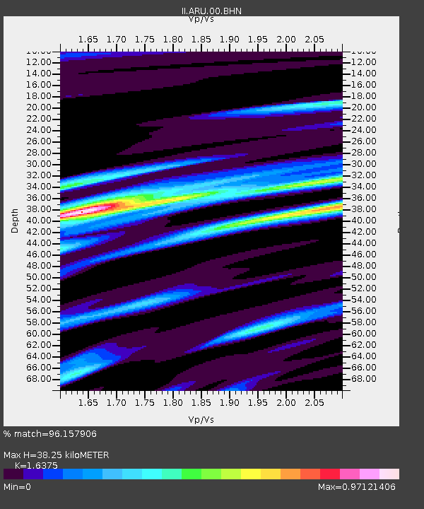
ARU Arti, Russia - Earthquake Result Viewer

Earthquake location: Northern Sumatra, Indonesia
Earthquake latitude/longitude: 2.9/96.2
Earthquake time(UTC): 1993/09/01 (244) 14:03:18 GMT
Earthquake Depth: 33 km
Earthquake Magnitude: 5.8 MB, 6.2 MS, 6.0 UNKNOWN, 6.2 MW
Earthquake Catalog/Contributor: WHDF/NEIC
Network: II Global Seismograph Network (GSN - IRIS/IDA)
Station: ARU Arti, Russia
Lat/Lon: 56.43 N/58.56 E
Elevation: 250 m
Distance: 61.2 deg
Az: 337.244 deg
Baz: 135.942 deg
Ray Param: 0.06098123
Estimated Moho Depth: 38.25 km
Estimated Crust Vp/Vs: 1.64
Assumed Crust Vp: 6.159 km/s
Estimated Crust Vs: 3.761 km/s
Estimated Crust Poisson's Ratio: 0.20
Radial Match: 96.157906 %
Radial Bump: 319
Transverse Match: 81.42366 %
Transverse Bump: 400
SOD ConfigId: 61242
Insert Time: 2010-03-01 16:40:20.247 +0000
GWidth: 2.5
Max Bumps: 400
Tol: 0.001

Signal To Noise

ChannelStoNSTALTA
II:ARU:00:BHN:19930901T14:12:59.54502Z3.44617444.1440362E-71.2025033E-7
II:ARU:00:BHE:19930901T14:12:59.54502Z3.98956973.3938014E-78.506685E-8
II:ARU:00:BHZ:19930901T14:12:59.54502Z20.324621.04349E-65.1341186E-8
Arrivals
Ps4.1 SECOND
PpPs16 SECOND
PsPs/PpSs20 SECOND