You are here: Home > Network List > XJ13 - CRAFTI Stations List
> Station PR31 Engaruka Boma > Earthquake Result Viewer
PR31 Engaruka Boma - Earthquake Result Viewer
| Earthquake location: |
Prince Edward Islands Region |
| Earthquake latitude/longitude: |
-46.4/33.8 |
| Earthquake time(UTC): |
2014/11/17 (321) 16:52:46 GMT |
| Earthquake Depth: |
10 km |
| Earthquake Magnitude: |
6.2 MWB |
| Earthquake Catalog/Contributor: |
NEIC PDE/NEIC COMCAT |
|
| Network: |
XJ CRAFTI |
| Station: |
PR31 Engaruka Boma |
| Lat/Lon: |
2.92 S/36.05 E |
| Elevation: |
884 m |
|
| Distance: |
43.3 deg |
| Az: |
3.311 deg |
| Baz: |
182.296 deg |
| Ray Param: |
0.07263493 |
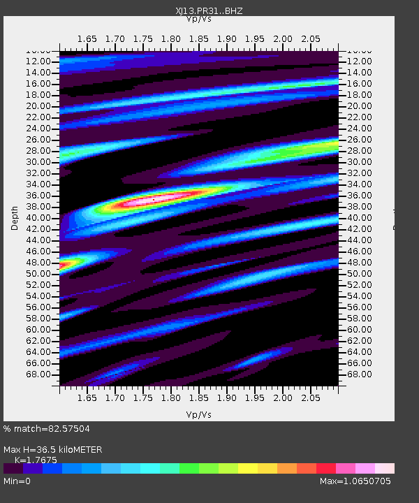
| Estimated Moho Depth: |
36.5 km |
| Estimated Crust Vp/Vs: |
1.77 |
| Assumed Crust Vp: |
6.601 km/s |
| Estimated Crust Vs: |
3.734 km/s |
| Estimated Crust Poisson's Ratio: |
0.26 |
|
| Radial Match: |
82.57504 % |
| Radial Bump: |
357 |
| Transverse Match: |
66.91201 % |
| Transverse Bump: |
400 |
| SOD ConfigId: |
3390531 |
| Insert Time: |
2019-04-15 02:06:14.295 +0000 |
| GWidth: |
2.5 |
| Max Bumps: |
400 |
| Tol: |
0.001 |
|

Signal To Noise
| Channel | StoN | STA | LTA |
| XJ:PR31: :BHZ:20141117T17:00:18.760015Z | 8.435509 | 5.8299423E-7 | 6.911193E-8 |
| XJ:PR31: :BHN:20141117T17:00:18.760015Z | 3.3265884 | 2.9520208E-7 | 8.8740194E-8 |
| XJ:PR31: :BHE:20141117T17:00:18.760015Z | 1.4723222 | 1.3674081E-7 | 9.2874245E-8 |
| Arrivals |
| Ps | 4.6 SECOND |
| PpPs | 14 SECOND |
| PsPs/PpSs | 19 SECOND |


