You are here: Home > Network List > US - United States National Seismic Network Stations List
> Station BLA Blacksburg, Virginia, USA > Earthquake Result Viewer
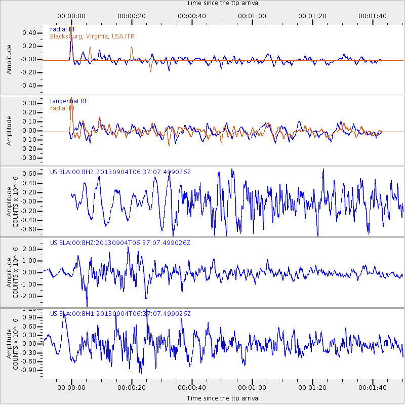
BLA Blacksburg, Virginia, USA - Earthquake Result Viewer
*The percent match for this event was below the threshold and hence no stack was calculated.
| Earthquake location: |
Andreanof Islands, Aleutian Is. |
| Earthquake latitude/longitude: |
51.6/-174.9 |
| Earthquake time(UTC): |
2013/09/04 (247) 06:27:03 GMT |
| Earthquake Depth: |
17 km |
| Earthquake Magnitude: |
6.0 MWW, 5.5 ML, 5.9 MWB, 6.0 MWW, 6.1 MWC, 6.1 MI |
| Earthquake Catalog/Contributor: |
NEIC PDE/NEIC COMCAT |
|
| Network: |
US United States National Seismic Network |
| Station: |
BLA Blacksburg, Virginia, USA |
| Lat/Lon: |
37.21 N/80.42 W |
| Elevation: |
634 m |
|
| Distance: |
64.4 deg |
| Az: |
61.956 deg |
| Baz: |
316.377 deg |
| Ray Param: |
$rayparam |
*The percent match for this event was below the threshold and hence was not used in the summary stack. |
|
| Radial Match: |
60.901592 % |
| Radial Bump: |
398 |
| Transverse Match: |
50.29805 % |
| Transverse Bump: |
400 |
| SOD ConfigId: |
626651 |
| Insert Time: |
2014-04-18 12:10:58.760 +0000 |
| GWidth: |
2.5 |
| Max Bumps: |
400 |
| Tol: |
0.001 |
|
Signal To Noise
| Channel | StoN | STA | LTA |
| US:BLA:00:BHZ:20130904T06:37:07.499026Z | 3.1669886 | 7.6572155E-7 | 2.4178223E-7 |
| US:BLA:00:BH1:20130904T06:37:07.499026Z | 1.4401207 | 3.426099E-7 | 2.379036E-7 |
| US:BLA:00:BH2:20130904T06:37:07.499026Z | 1.772408 | 4.3719092E-7 | 2.4666497E-7 |
| Arrivals |
| Ps | |
| PpPs | |
| PsPs/PpSs | |


