You are here: Home > Network List > CI - Caltech Regional Seismic Network Stations List
> Station TIN Tinemaha, California, USA > Earthquake Result Viewer
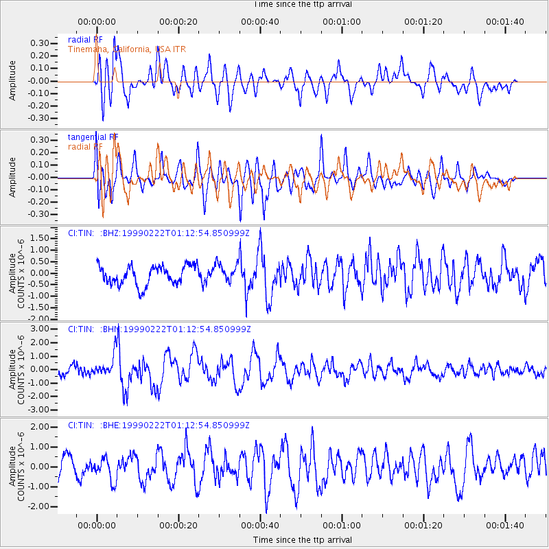
TIN Tinemaha, California, USA - Earthquake Result Viewer
*The percent match for this event was below the threshold and hence no stack was calculated.
| Earthquake location: |
Southeast Of Loyalty Islands |
| Earthquake latitude/longitude: |
-21.5/169.7 |
| Earthquake time(UTC): |
1999/02/22 (053) 01:00:32 GMT |
| Earthquake Depth: |
33 km |
| Earthquake Magnitude: |
5.8 MB, 6.4 MS, 6.5 MW, 6.4 MW |
| Earthquake Catalog/Contributor: |
WHDF/NEIC |
|
| Network: |
CI Caltech Regional Seismic Network |
| Station: |
TIN Tinemaha, California, USA |
| Lat/Lon: |
37.05 N/118.23 W |
| Elevation: |
1164 m |
|
| Distance: |
89.4 deg |
| Az: |
49.577 deg |
| Baz: |
242.431 deg |
| Ray Param: |
$rayparam |
*The percent match for this event was below the threshold and hence was not used in the summary stack. |
|
| Radial Match: |
73.5825 % |
| Radial Bump: |
400 |
| Transverse Match: |
74.56531 % |
| Transverse Bump: |
400 |
| SOD ConfigId: |
4480 |
| Insert Time: |
2010-02-25 20:51:53.670 +0000 |
| GWidth: |
2.5 |
| Max Bumps: |
400 |
| Tol: |
0.001 |
|
Signal To Noise
| Channel | StoN | STA | LTA |
| CI:TIN: :BHN:19990222T01:12:54.850999Z | 2.392659 | 8.1956415E-7 | 3.4253281E-7 |
| CI:TIN: :BHE:19990222T01:12:54.850999Z | 1.3789425 | 6.047716E-7 | 4.3857642E-7 |
| CI:TIN: :BHZ:19990222T01:12:54.850999Z | 0.97924286 | 4.0905954E-7 | 4.177304E-7 |
| Arrivals |
| Ps | |
| PpPs | |
| PsPs/PpSs | |


