You are here: Home > Network List > YQ13 - Study of Extension and Magmatism in Malawi and Tanzania Stations List
> Station BUMI Ibumi,Tanzania > Earthquake Result Viewer
BUMI Ibumi,Tanzania - Earthquake Result Viewer
| Earthquake location: |
Prince Edward Islands Region |
| Earthquake latitude/longitude: |
-46.4/33.8 |
| Earthquake time(UTC): |
2014/11/17 (321) 16:52:46 GMT |
| Earthquake Depth: |
10 km |
| Earthquake Magnitude: |
6.2 MWB |
| Earthquake Catalog/Contributor: |
NEIC PDE/NEIC COMCAT |
|
| Network: |
YQ Study of Extension and Magmatism in Malawi and Tanzania |
| Station: |
BUMI Ibumi,Tanzania |
| Lat/Lon: |
10.13 S/34.94 E |
| Elevation: |
1333 m |
|
| Distance: |
36.1 deg |
| Az: |
1.942 deg |
| Baz: |
181.366 deg |
| Ray Param: |
0.07685598 |
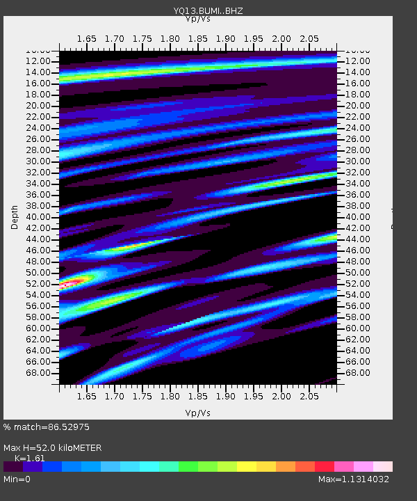
| Estimated Moho Depth: |
52.0 km |
| Estimated Crust Vp/Vs: |
1.61 |
| Assumed Crust Vp: |
6.502 km/s |
| Estimated Crust Vs: |
4.038 km/s |
| Estimated Crust Poisson's Ratio: |
0.19 |
|
| Radial Match: |
86.52975 % |
| Radial Bump: |
389 |
| Transverse Match: |
59.033306 % |
| Transverse Bump: |
400 |
| SOD ConfigId: |
3390531 |
| Insert Time: |
2019-04-15 02:07:25.027 +0000 |
| GWidth: |
2.5 |
| Max Bumps: |
400 |
| Tol: |
0.001 |
|

Signal To Noise
| Channel | StoN | STA | LTA |
| YQ:BUMI: :BHZ:20141117T16:59:19.010015Z | 5.97726 | 7.508506E-7 | 1.2561786E-7 |
| YQ:BUMI: :BHN:20141117T16:59:19.010015Z | 3.235024 | 5.6978644E-7 | 1.7613051E-7 |
| YQ:BUMI: :BHE:20141117T16:59:19.010015Z | 1.1424402 | 2.1982817E-7 | 1.9241985E-7 |
| Arrivals |
| Ps | 5.3 SECOND |
| PpPs | 19 SECOND |
| PsPs/PpSs | 24 SECOND |


