You are here: Home > Network List > YQ13 - Study of Extension and Magmatism in Malawi and Tanzania Stations List
> Station GAWA Igawa,Tanzania > Earthquake Result Viewer
GAWA Igawa,Tanzania - Earthquake Result Viewer
| Earthquake location: |
Prince Edward Islands Region |
| Earthquake latitude/longitude: |
-46.4/33.8 |
| Earthquake time(UTC): |
2014/11/17 (321) 16:52:46 GMT |
| Earthquake Depth: |
10 km |
| Earthquake Magnitude: |
6.2 MWB |
| Earthquake Catalog/Contributor: |
NEIC PDE/NEIC COMCAT |
|
| Network: |
YQ Study of Extension and Magmatism in Malawi and Tanzania |
| Station: |
GAWA Igawa,Tanzania |
| Lat/Lon: |
8.76 S/34.39 E |
| Elevation: |
1127 m |
|
| Distance: |
37.5 deg |
| Az: |
0.995 deg |
| Baz: |
180.697 deg |
| Ray Param: |
0.07612367 |
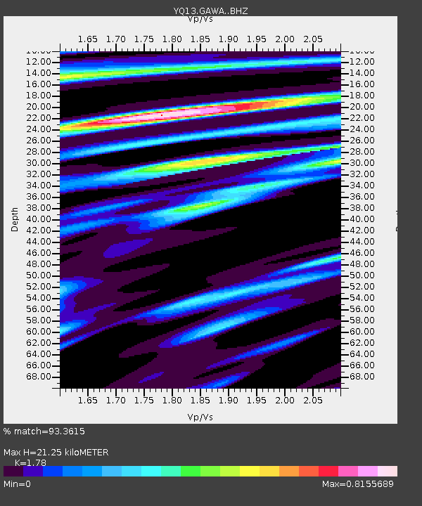
| Estimated Moho Depth: |
21.25 km |
| Estimated Crust Vp/Vs: |
1.78 |
| Assumed Crust Vp: |
6.576 km/s |
| Estimated Crust Vs: |
3.695 km/s |
| Estimated Crust Poisson's Ratio: |
0.27 |
|
| Radial Match: |
93.3615 % |
| Radial Bump: |
281 |
| Transverse Match: |
65.407524 % |
| Transverse Bump: |
400 |
| SOD ConfigId: |
3390531 |
| Insert Time: |
2019-04-15 02:07:28.475 +0000 |
| GWidth: |
2.5 |
| Max Bumps: |
400 |
| Tol: |
0.001 |
|

Signal To Noise
| Channel | StoN | STA | LTA |
| YQ:GAWA: :BHZ:20141117T16:59:30.429998Z | 9.42167 | 6.958212E-7 | 7.385327E-8 |
| YQ:GAWA: :BHN:20141117T16:59:30.429998Z | 6.0253716 | 4.0686476E-7 | 6.752526E-8 |
| YQ:GAWA: :BHE:20141117T16:59:30.429998Z | 1.3222432 | 8.47476E-8 | 6.4093804E-8 |
| Arrivals |
| Ps | 2.7 SECOND |
| PpPs | 8.3 SECOND |
| PsPs/PpSs | 11 SECOND |


