You are here: Home > Network List > II - Global Seismograph Network (GSN - IRIS/IDA) Stations List
> Station ARU Arti, Russia > Earthquake Result Viewer
ARU Arti, Russia - Earthquake Result Viewer
| Earthquake location: |
South Of Java, Indonesia |
| Earthquake latitude/longitude: |
-10.5/113.0 |
| Earthquake time(UTC): |
1994/06/02 (153) 18:17:36 GMT |
| Earthquake Depth: |
39 km |
| Earthquake Magnitude: |
5.5 MB, 7.2 MS, 6.8 UNKNOWN, 7.7 MW |
| Earthquake Catalog/Contributor: |
WHDF/NEIC |
|
| Network: |
II Global Seismograph Network (GSN - IRIS/IDA) |
| Station: |
ARU Arti, Russia |
| Lat/Lon: |
56.43 N/58.56 E |
| Elevation: |
250 m |
|
| Distance: |
80.3 deg |
| Az: |
332.724 deg |
| Baz: |
125.77 deg |
| Ray Param: |
0.04828412 |
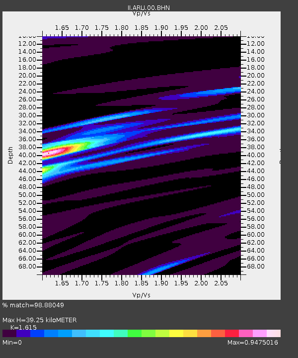
| Estimated Moho Depth: |
39.25 km |
| Estimated Crust Vp/Vs: |
1.62 |
| Assumed Crust Vp: |
6.159 km/s |
| Estimated Crust Vs: |
3.813 km/s |
| Estimated Crust Poisson's Ratio: |
0.19 |
|
| Radial Match: |
98.88049 % |
| Radial Bump: |
213 |
| Transverse Match: |
81.763336 % |
| Transverse Bump: |
400 |
| SOD ConfigId: |
61242 |
| Insert Time: |
2010-03-01 16:41:08.721 +0000 |
| GWidth: |
2.5 |
| Max Bumps: |
400 |
| Tol: |
0.001 |
|
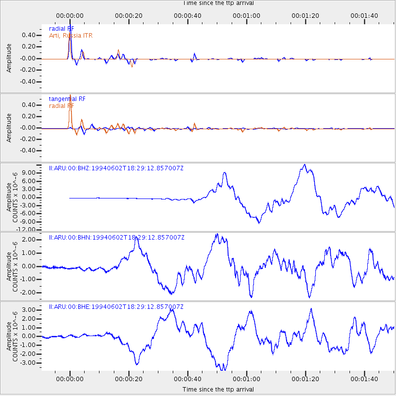
Signal To Noise
| Channel | StoN | STA | LTA |
| II:ARU:00:BHN:19940602T18:29:12.857007Z | 2.3409386 | 1.4850086E-7 | 6.343646E-8 |
| II:ARU:00:BHE:19940602T18:29:12.857007Z | 3.0263965 | 2.1753867E-7 | 7.188042E-8 |
| II:ARU:00:BHZ:19940602T18:29:12.857007Z | 5.2538643 | 3.276416E-7 | 6.236202E-8 |
| Arrivals |
| Ps | 4.0 SECOND |
| PpPs | 16 SECOND |
| PsPs/PpSs | 20 SECOND |


