You are here: Home > Network List > YQ13 - Study of Extension and Magmatism in Malawi and Tanzania Stations List
> Station KURU Muhukuru,Tanzania > Earthquake Result Viewer
KURU Muhukuru,Tanzania - Earthquake Result Viewer
| Earthquake location: |
Prince Edward Islands Region |
| Earthquake latitude/longitude: |
-46.4/33.8 |
| Earthquake time(UTC): |
2014/11/17 (321) 16:52:46 GMT |
| Earthquake Depth: |
10 km |
| Earthquake Magnitude: |
6.2 MWB |
| Earthquake Catalog/Contributor: |
NEIC PDE/NEIC COMCAT |
|
| Network: |
YQ Study of Extension and Magmatism in Malawi and Tanzania |
| Station: |
KURU Muhukuru,Tanzania |
| Lat/Lon: |
11.20 S/35.46 E |
| Elevation: |
751 m |
|
| Distance: |
35.1 deg |
| Az: |
2.876 deg |
| Baz: |
182.03 deg |
| Ray Param: |
0.07741671 |
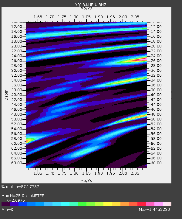
| Estimated Moho Depth: |
25.0 km |
| Estimated Crust Vp/Vs: |
2.10 |
| Assumed Crust Vp: |
6.502 km/s |
| Estimated Crust Vs: |
3.1 km/s |
| Estimated Crust Poisson's Ratio: |
0.35 |
|
| Radial Match: |
87.17737 % |
| Radial Bump: |
304 |
| Transverse Match: |
55.592903 % |
| Transverse Bump: |
400 |
| SOD ConfigId: |
3390531 |
| Insert Time: |
2019-04-15 02:07:36.960 +0000 |
| GWidth: |
2.5 |
| Max Bumps: |
400 |
| Tol: |
0.001 |
|

Signal To Noise
| Channel | StoN | STA | LTA |
| YQ:KURU: :BHZ:20141117T16:59:10.040013Z | 12.781517 | 1.6911218E-6 | 1.3230995E-7 |
| YQ:KURU: :BHN:20141117T16:59:10.040013Z | 7.039796 | 1.006027E-6 | 1.429057E-7 |
| YQ:KURU: :BHE:20141117T16:59:10.040013Z | 1.483245 | 1.9947385E-7 | 1.3448476E-7 |
| Arrivals |
| Ps | 4.5 SECOND |
| PpPs | 11 SECOND |
| PsPs/PpSs | 16 SECOND |


