You are here: Home > Network List > YQ13 - Study of Extension and Magmatism in Malawi and Tanzania Stations List
> Station ZINI Mgazini,Tanzania > Earthquake Result Viewer
ZINI Mgazini,Tanzania - Earthquake Result Viewer
| Earthquake location: |
Prince Edward Islands Region |
| Earthquake latitude/longitude: |
-46.4/33.8 |
| Earthquake time(UTC): |
2014/11/17 (321) 16:52:46 GMT |
| Earthquake Depth: |
10 km |
| Earthquake Magnitude: |
6.2 MWB |
| Earthquake Catalog/Contributor: |
NEIC PDE/NEIC COMCAT |
|
| Network: |
YQ Study of Extension and Magmatism in Malawi and Tanzania |
| Station: |
ZINI Mgazini,Tanzania |
| Lat/Lon: |
10.47 S/35.34 E |
| Elevation: |
1044 m |
|
| Distance: |
35.8 deg |
| Az: |
2.631 deg |
| Baz: |
181.853 deg |
| Ray Param: |
0.07703294 |
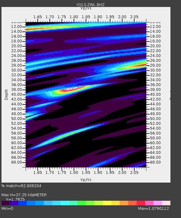
| Estimated Moho Depth: |
37.25 km |
| Estimated Crust Vp/Vs: |
1.79 |
| Assumed Crust Vp: |
6.502 km/s |
| Estimated Crust Vs: |
3.627 km/s |
| Estimated Crust Poisson's Ratio: |
0.27 |
|
| Radial Match: |
92.809204 % |
| Radial Bump: |
400 |
| Transverse Match: |
59.829067 % |
| Transverse Bump: |
400 |
| SOD ConfigId: |
3390531 |
| Insert Time: |
2019-04-15 02:07:53.746 +0000 |
| GWidth: |
2.5 |
| Max Bumps: |
400 |
| Tol: |
0.001 |
|

Signal To Noise
| Channel | StoN | STA | LTA |
| YQ:ZINI: :BHZ:20141117T16:59:16.239995Z | 12.77976 | 1.2146756E-6 | 9.504682E-8 |
| YQ:ZINI: :BHN:20141117T16:59:16.239995Z | 5.8633657 | 7.5499696E-7 | 1.2876512E-7 |
| YQ:ZINI: :BHE:20141117T16:59:16.239995Z | 1.4500914 | 1.9739657E-7 | 1.3612699E-7 |
| Arrivals |
| Ps | 4.9 SECOND |
| PpPs | 15 SECOND |
| PsPs/PpSs | 20 SECOND |


