You are here: Home > Network List > ZJ12 - Transantarctic Mountains Northern Network Stations List
> Station SHRD Lister Nunataks, Antarctica > Earthquake Result Viewer
SHRD Lister Nunataks, Antarctica - Earthquake Result Viewer
| Earthquake location: |
Prince Edward Islands Region |
| Earthquake latitude/longitude: |
-46.4/33.8 |
| Earthquake time(UTC): |
2014/11/17 (321) 16:52:46 GMT |
| Earthquake Depth: |
10 km |
| Earthquake Magnitude: |
6.2 MWB |
| Earthquake Catalog/Contributor: |
NEIC PDE/NEIC COMCAT |
|
| Network: |
ZJ Transantarctic Mountains Northern Network |
| Station: |
SHRD Lister Nunataks, Antarctica |
| Lat/Lon: |
73.40 S/160.50 E |
| Elevation: |
2457 m |
|
| Distance: |
55.1 deg |
| Az: |
163.688 deg |
| Baz: |
222.584 deg |
| Ray Param: |
0.06500182 |
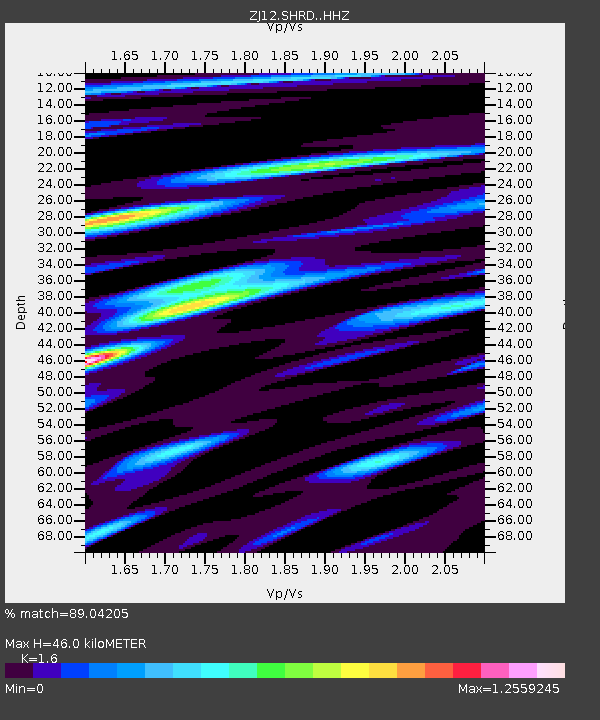
| Estimated Moho Depth: |
46.0 km |
| Estimated Crust Vp/Vs: |
1.60 |
| Assumed Crust Vp: |
6.264 km/s |
| Estimated Crust Vs: |
3.915 km/s |
| Estimated Crust Poisson's Ratio: |
0.18 |
|
| Radial Match: |
89.04205 % |
| Radial Bump: |
400 |
| Transverse Match: |
77.678276 % |
| Transverse Bump: |
400 |
| SOD ConfigId: |
3390531 |
| Insert Time: |
2019-04-15 02:08:14.717 +0000 |
| GWidth: |
2.5 |
| Max Bumps: |
400 |
| Tol: |
0.001 |
|

Signal To Noise
| Channel | StoN | STA | LTA |
| ZJ:SHRD: :HHZ:20141117T17:01:48.299016Z | 17.56474 | 1.2511949E-6 | 7.123334E-8 |
| ZJ:SHRD: :HHN:20141117T17:01:48.299016Z | 10.490978 | 5.6878E-7 | 5.421611E-8 |
| ZJ:SHRD: :HHE:20141117T17:01:48.299016Z | 8.796533 | 5.6637504E-7 | 6.438617E-8 |
| Arrivals |
| Ps | 4.7 SECOND |
| PpPs | 18 SECOND |
| PsPs/PpSs | 23 SECOND |


