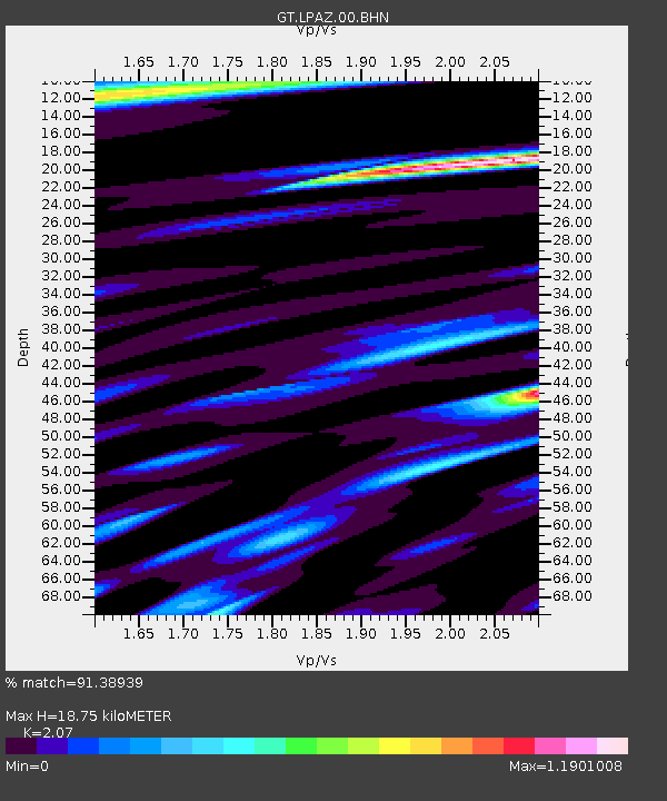
LPAZ La Paz , Bolivia - Earthquake Result Viewer
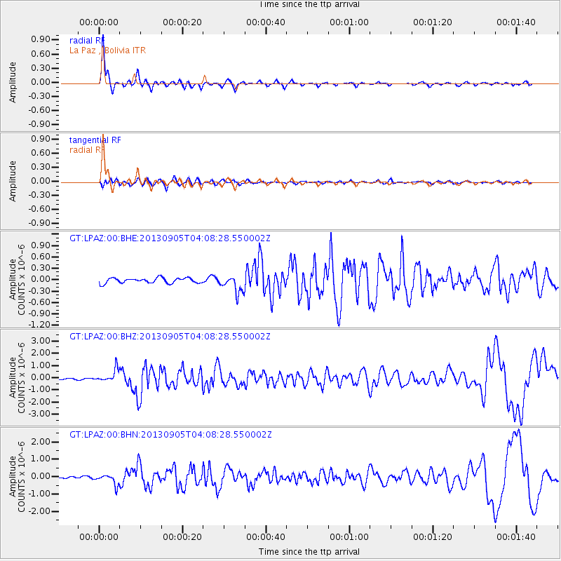
Earthquake location: Northern Mid-Atlantic Ridge
Earthquake latitude/longitude: 15.2/-45.2
Earthquake time(UTC): 2013/09/05 (248) 04:01:36 GMT
Earthquake Depth: 10 km
Earthquake Magnitude: 6.0 MWW, 5.9 MWB, 6.0 MWW, 6.0 MWC
Earthquake Catalog/Contributor: NEIC PDE/NEIC COMCAT
Network: GT Global Telemetered Seismograph Network (USAF/USGS)
Station: LPAZ La Paz , Bolivia
Lat/Lon: 16.17 S/68.08 W
Elevation: 4817 m
Distance: 38.5 deg
Az: 216.853 deg
Baz: 37.059 deg
Ray Param: 0.07554523
Estimated Moho Depth: 18.75 km
Estimated Crust Vp/Vs: 2.07
Assumed Crust Vp: 6.454 km/s
Estimated Crust Vs: 3.118 km/s
Estimated Crust Poisson's Ratio: 0.35
Radial Match: 91.38939 %
Radial Bump: 255
Transverse Match: 73.554054 %
Transverse Bump: 400
SOD ConfigId: 626651
Insert Time: 2014-04-18 12:28:45.178 +0000
GWidth: 2.5
Max Bumps: 400
Tol: 0.001

Signal To Noise

ChannelStoNSTALTA
GT:LPAZ:00:BHZ:20130905T04:08:28.550002Z9.1569575.457623E-75.960084E-8
GT:LPAZ:00:BHN:20130905T04:08:28.550002Z4.77740673.1807917E-76.657988E-8
GT:LPAZ:00:BHE:20130905T04:08:28.550002Z3.00904152.0540126E-76.826136E-8
Arrivals
Ps3.3 SECOND
PpPs8.4 SECOND
PsPs/PpSs12 SECOND