PANJ Princeton, NJ - Earthquake Result Viewer
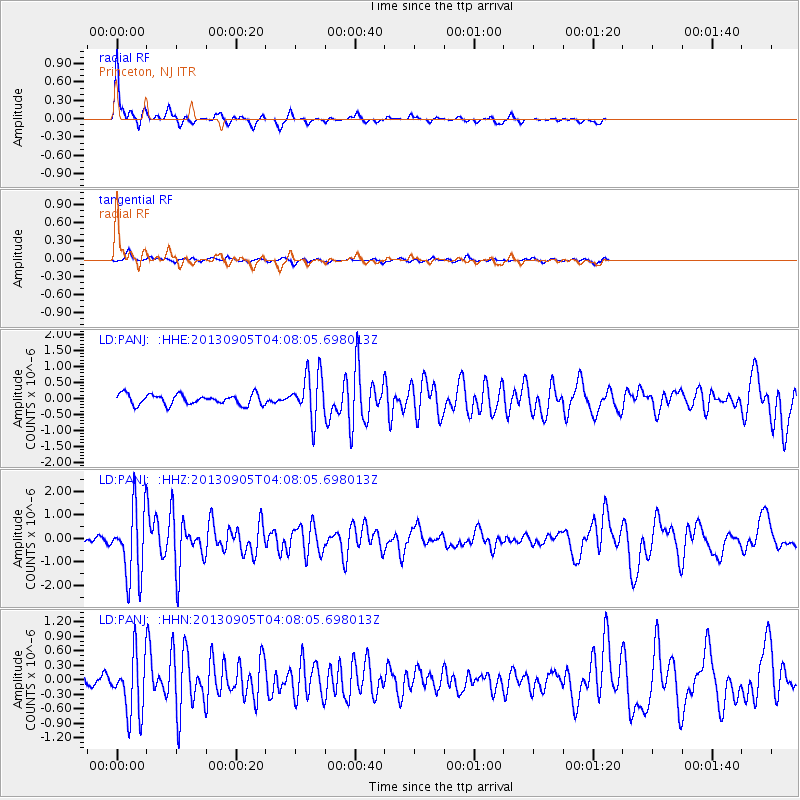
Earthquake location: Northern Mid-Atlantic Ridge
Earthquake latitude/longitude: 15.2/-45.2
Earthquake time(UTC): 2013/09/05 (248) 04:01:36 GMT
Earthquake Depth: 10 km
Earthquake Magnitude: 6.0 MWW, 5.9 MWB, 6.0 MWW, 6.0 MWC
Earthquake Catalog/Contributor: NEIC PDE/NEIC COMCAT
Network: LD Lamont-Doherty Cooperative Seismographic Network
Station: PANJ Princeton, NJ
Lat/Lon: 40.38 N/74.70 W
Elevation: 100 m
Distance: 35.9 deg
Az: 320.127 deg
Baz: 125.878 deg
Ray Param: 0.07697801
Estimated Moho Depth: 23.0 km
Estimated Crust Vp/Vs: 1.60
Assumed Crust Vp: 6.283 km/s
Estimated Crust Vs: 3.927 km/s
Estimated Crust Poisson's Ratio: 0.18
Radial Match: 90.93816 %
Radial Bump: 295
Transverse Match: 57.88464 %
Transverse Bump: 364
SOD ConfigId: 626651
Insert Time: 2014-04-18 12:32:18.013 +0000
GWidth: 2.5
Max Bumps: 400
Tol: 0.001

Signal To Noise

ChannelStoNSTALTA
LD:PANJ: :HHZ:20130905T04:08:05.698013Z6.9624371.4987245E-62.152586E-7
LD:PANJ: :HHN:20130905T04:08:05.698013Z3.0571516.25135E-72.0448286E-7
LD:PANJ: :HHE:20130905T04:08:05.698013Z4.3977827.187499E-71.6343465E-7
Arrivals
Ps2.4 SECOND
PpPs8.8 SECOND
PsPs/PpSs11 SECOND