You are here: Home > Network List > NE - New England Seismic Network Stations List
> Station HNH Hanover, NH, USA > Earthquake Result Viewer
HNH Hanover, NH, USA - Earthquake Result Viewer
| Earthquake location: |
Northern Mid-Atlantic Ridge |
| Earthquake latitude/longitude: |
15.2/-45.2 |
| Earthquake time(UTC): |
2013/09/05 (248) 04:01:36 GMT |
| Earthquake Depth: |
10 km |
| Earthquake Magnitude: |
6.0 MWW, 5.9 MWB, 6.0 MWW, 6.0 MWC |
| Earthquake Catalog/Contributor: |
NEIC PDE/NEIC COMCAT |
|
| Network: |
NE New England Seismic Network |
| Station: |
HNH Hanover, NH, USA |
| Lat/Lon: |
43.71 N/72.29 W |
| Elevation: |
180 m |
|
| Distance: |
36.6 deg |
| Az: |
326.411 deg |
| Baz: |
132.561 deg |
| Ray Param: |
0.07659187 |
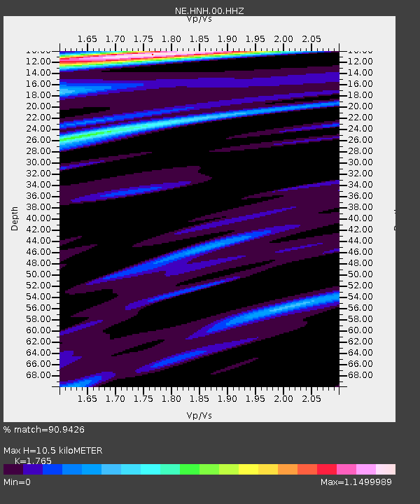
| Estimated Moho Depth: |
10.5 km |
| Estimated Crust Vp/Vs: |
1.76 |
| Assumed Crust Vp: |
6.419 km/s |
| Estimated Crust Vs: |
3.637 km/s |
| Estimated Crust Poisson's Ratio: |
0.26 |
|
| Radial Match: |
90.9426 % |
| Radial Bump: |
284 |
| Transverse Match: |
71.337234 % |
| Transverse Bump: |
357 |
| SOD ConfigId: |
626651 |
| Insert Time: |
2014-04-18 12:33:05.777 +0000 |
| GWidth: |
2.5 |
| Max Bumps: |
400 |
| Tol: |
0.001 |
|

Signal To Noise
| Channel | StoN | STA | LTA |
| NE:HNH:00:HHZ:20130905T04:08:11.738998Z | 3.9853077 | 1.2023182E-6 | 3.016877E-7 |
| NE:HNH:00:HH1:20130905T04:08:11.738998Z | 1.7304156 | 3.4333812E-7 | 1.9841367E-7 |
| NE:HNH:00:HH2:20130905T04:08:11.738998Z | 3.0848851 | 7.282681E-7 | 2.3607623E-7 |
| Arrivals |
| Ps | 1.3 SECOND |
| PpPs | 4.2 SECOND |
| PsPs/PpSs | 5.5 SECOND |


