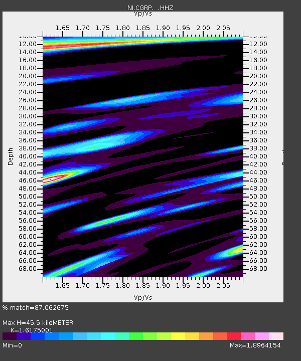
CGRP Cima Grappa - Earthquake Result Viewer
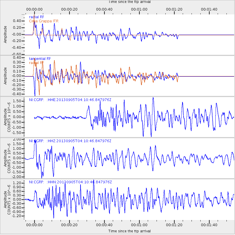
Earthquake location: Northern Mid-Atlantic Ridge
Earthquake latitude/longitude: 15.2/-45.2
Earthquake time(UTC): 2013/09/05 (248) 04:01:36 GMT
Earthquake Depth: 10 km
Earthquake Magnitude: 6.0 MWW, 5.9 MWB, 6.0 MWW, 6.0 MWC
Earthquake Catalog/Contributor: NEIC PDE/NEIC COMCAT
Network: NI North-East Italy Broadband Network
Station: CGRP Cima Grappa
Lat/Lon: 45.88 N/11.80 E
Elevation: 1757 m
Distance: 56.4 deg
Az: 44.715 deg
Baz: 256.526 deg
Ray Param: 0.064159535
Estimated Moho Depth: 45.5 km
Estimated Crust Vp/Vs: 1.62
Assumed Crust Vp: 6.155 km/s
Estimated Crust Vs: 3.805 km/s
Estimated Crust Poisson's Ratio: 0.19
Radial Match: 87.062675 %
Radial Bump: 400
Transverse Match: 83.763016 %
Transverse Bump: 400
SOD ConfigId: 626651
Insert Time: 2014-04-18 12:33:33.937 +0000
GWidth: 2.5
Max Bumps: 400
Tol: 0.001

Signal To Noise

ChannelStoNSTALTA
NI:CGRP: :HHZ:20130905T04:10:46.847976Z10.8832011.1339764E-61.0419512E-7
NI:CGRP: :HHN:20130905T04:10:46.847976Z7.9788483.7328334E-74.6784116E-8
NI:CGRP: :HHE:20130905T04:10:46.847976Z9.8881075.9738795E-76.041479E-8
Arrivals
Ps4.8 SECOND
PpPs18 SECOND
PsPs/PpSs23 SECOND