You are here: Home > Network List > TA - USArray Transportable Network (new EarthScope stations) Stations List
> Station A21K Barrow, AK, USA > Earthquake Result Viewer
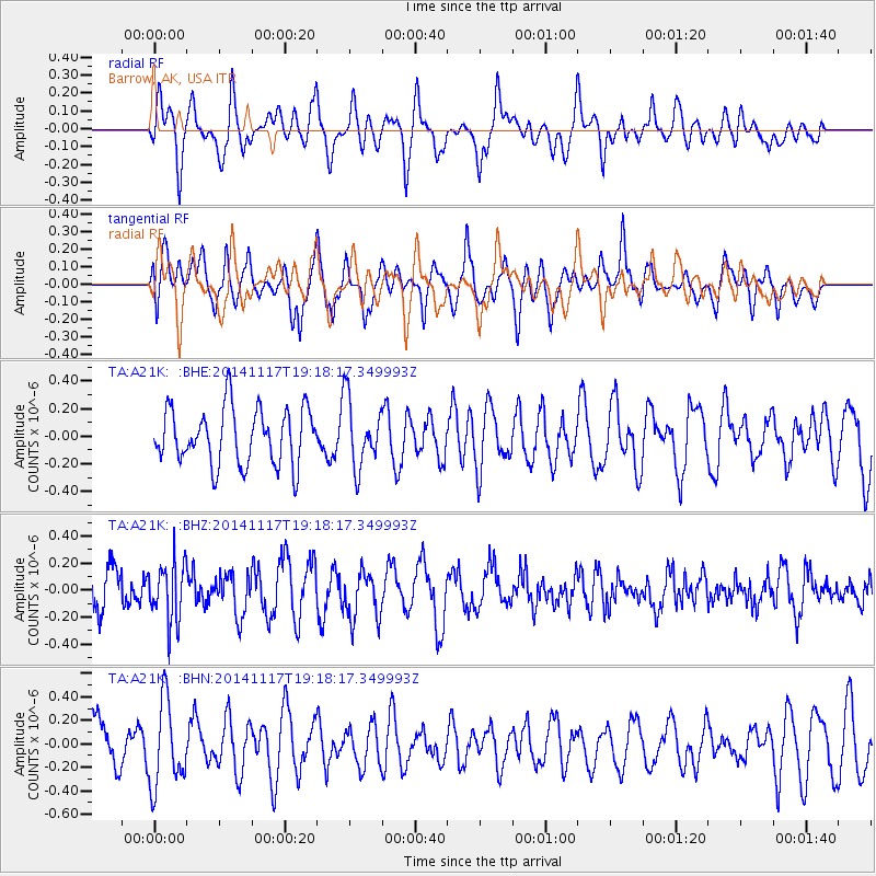
A21K Barrow, AK, USA - Earthquake Result Viewer
*The percent match for this event was below the threshold and hence no stack was calculated.
| Earthquake location: |
Flores Sea |
| Earthquake latitude/longitude: |
-7.1/120.4 |
| Earthquake time(UTC): |
2014/11/17 (321) 19:06:31 GMT |
| Earthquake Depth: |
591 km |
| Earthquake Magnitude: |
5.1 mb, 5.0 mb |
| Earthquake Catalog/Contributor: |
ISC/ISC |
|
| Network: |
TA USArray Transportable Network (new EarthScope stations) |
| Station: |
A21K Barrow, AK, USA |
| Lat/Lon: |
71.32 N/156.62 W |
| Elevation: |
577 m |
|
| Distance: |
94.4 deg |
| Az: |
18.706 deg |
| Baz: |
261.091 deg |
| Ray Param: |
$rayparam |
*The percent match for this event was below the threshold and hence was not used in the summary stack. |
|
| Radial Match: |
48.27451 % |
| Radial Bump: |
400 |
| Transverse Match: |
68.86307 % |
| Transverse Bump: |
400 |
| SOD ConfigId: |
3390531 |
| Insert Time: |
2019-04-15 02:13:39.968 +0000 |
| GWidth: |
2.5 |
| Max Bumps: |
400 |
| Tol: |
0.001 |
|
Signal To Noise
| Channel | StoN | STA | LTA |
| TA:A21K: :BHZ:20141117T19:18:17.349993Z | 1.3403141 | 2.1681916E-7 | 1.6176742E-7 |
| TA:A21K: :BHN:20141117T19:18:17.349993Z | 2.230912 | 3.6346339E-7 | 1.6292142E-7 |
| TA:A21K: :BHE:20141117T19:18:17.349993Z | 1.2106866 | 2.4575792E-7 | 2.0299053E-7 |
| Arrivals |
| Ps | |
| PpPs | |
| PsPs/PpSs | |


