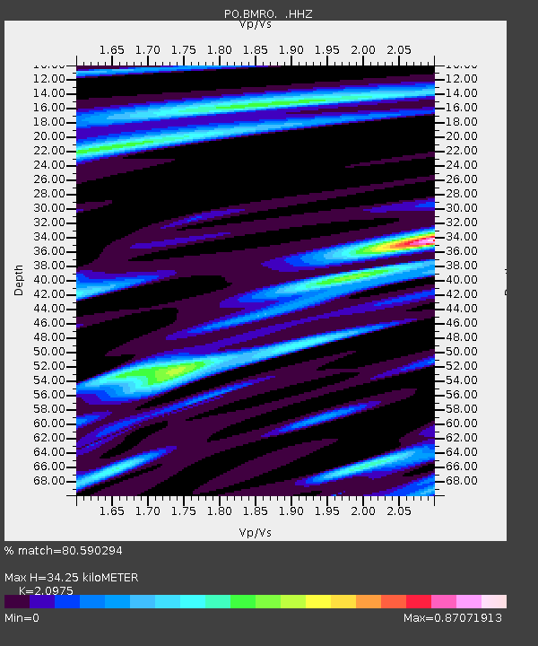
BMRO Maryville Lake, ON, CANADA.A - Earthquake Result Viewer

Earthquake location: Northern Mid-Atlantic Ridge
Earthquake latitude/longitude: 15.2/-45.2
Earthquake time(UTC): 2013/09/05 (248) 04:01:36 GMT
Earthquake Depth: 10 km
Earthquake Magnitude: 6.0 MWW, 5.9 MWB, 6.0 MWW, 6.0 MWC
Earthquake Catalog/Contributor: NEIC PDE/NEIC COMCAT
Network: PO Portable Observatories for Lithospheric Analysis and Research Investigating Seis
Station: BMRO Maryville Lake, ON, CANADA.A
Lat/Lon: 44.60 N/81.22 W
Elevation: 217 m
Distance: 42.2 deg
Az: 321.36 deg
Baz: 122.448 deg
Ray Param: 0.073286355
Estimated Moho Depth: 34.25 km
Estimated Crust Vp/Vs: 2.10
Assumed Crust Vp: 6.53 km/s
Estimated Crust Vs: 3.113 km/s
Estimated Crust Poisson's Ratio: 0.35
Radial Match: 80.590294 %
Radial Bump: 267
Transverse Match: 55.071377 %
Transverse Bump: 400
SOD ConfigId: 626651
Insert Time: 2014-04-18 12:36:51.003 +0000
GWidth: 2.5
Max Bumps: 400
Tol: 0.001

Signal To Noise

ChannelStoNSTALTA
PO:BMRO: :HHZ:20130905T04:08:58.750015Z6.0627041.4108064E-62.3270249E-7
PO:BMRO: :HHN:20130905T04:08:58.750015Z2.72761735.768441E-72.114828E-7
PO:BMRO: :HHE:20130905T04:08:58.750015Z3.36134178.8123426E-72.6216742E-7
Arrivals
Ps6.1 SECOND
PpPs15 SECOND
PsPs/PpSs21 SECOND