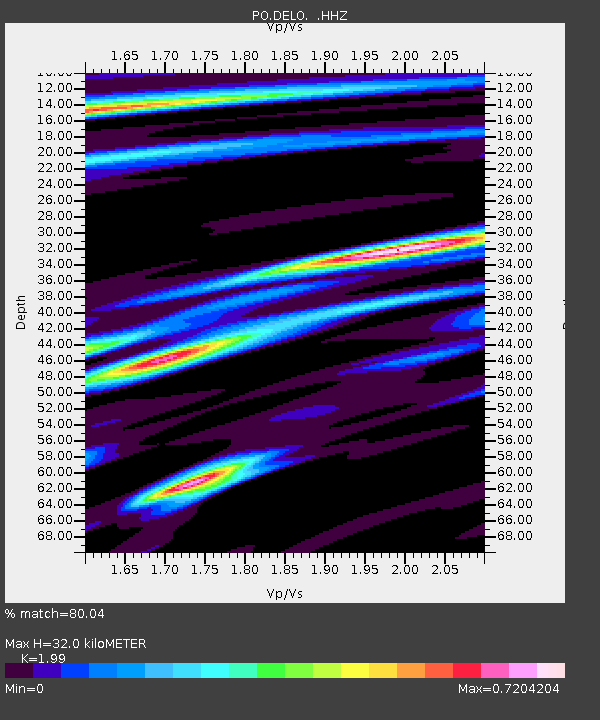
DELO DELORO MINE, ON - Earthquake Result Viewer

Earthquake location: Northern Mid-Atlantic Ridge
Earthquake latitude/longitude: 15.2/-45.2
Earthquake time(UTC): 2013/09/05 (248) 04:01:36 GMT
Earthquake Depth: 10 km
Earthquake Magnitude: 6.0 MWW, 5.9 MWB, 6.0 MWW, 6.0 MWC
Earthquake Catalog/Contributor: NEIC PDE/NEIC COMCAT
Network: PO Portable Observatories for Lithospheric Analysis and Research Investigating Seis
Station: DELO DELORO MINE, ON
Lat/Lon: 44.52 N/77.62 W
Elevation: 213 m
Distance: 40.1 deg
Az: 323.477 deg
Baz: 126.559 deg
Ray Param: 0.07460099
Estimated Moho Depth: 32.0 km
Estimated Crust Vp/Vs: 1.99
Assumed Crust Vp: 6.577 km/s
Estimated Crust Vs: 3.305 km/s
Estimated Crust Poisson's Ratio: 0.33
Radial Match: 80.04 %
Radial Bump: 219
Transverse Match: 62.68637 %
Transverse Bump: 390
SOD ConfigId: 626651
Insert Time: 2014-04-18 12:37:03.663 +0000
GWidth: 2.5
Max Bumps: 400
Tol: 0.001

Signal To Noise

ChannelStoNSTALTA
PO:DELO: :HHZ:20130905T04:08:40.979995Z6.55716856.521831E-79.946108E-8
PO:DELO: :HHN:20130905T04:08:40.979995Z3.06764942.1109683E-76.8813875E-8
PO:DELO: :HHE:20130905T04:08:40.979995Z4.83046672.8433348E-75.8862526E-8
Arrivals
Ps5.1 SECOND
PpPs14 SECOND
PsPs/PpSs19 SECOND