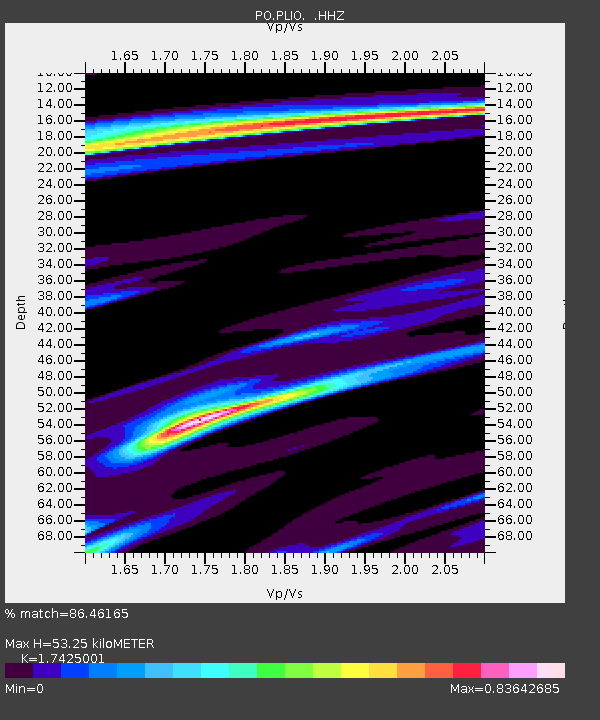
PLIO PELEE ISLAND, ON - Earthquake Result Viewer

Earthquake location: Northern Mid-Atlantic Ridge
Earthquake latitude/longitude: 15.2/-45.2
Earthquake time(UTC): 2013/09/05 (248) 04:01:36 GMT
Earthquake Depth: 10 km
Earthquake Magnitude: 6.0 MWW, 5.9 MWB, 6.0 MWW, 6.0 MWC
Earthquake Catalog/Contributor: NEIC PDE/NEIC COMCAT
Network: PO Portable Observatories for Lithospheric Analysis and Research Investigating Seis
Station: PLIO PELEE ISLAND, ON
Lat/Lon: 41.75 N/82.63 W
Elevation: 143 m
Distance: 41.7 deg
Az: 316.91 deg
Baz: 118.177 deg
Ray Param: 0.0736269
Estimated Moho Depth: 53.25 km
Estimated Crust Vp/Vs: 1.74
Assumed Crust Vp: 6.498 km/s
Estimated Crust Vs: 3.729 km/s
Estimated Crust Poisson's Ratio: 0.25
Radial Match: 86.46165 %
Radial Bump: 293
Transverse Match: 73.538895 %
Transverse Bump: 400
SOD ConfigId: 626651
Insert Time: 2014-04-18 12:37:40.158 +0000
GWidth: 2.5
Max Bumps: 400
Tol: 0.001

Signal To Noise

ChannelStoNSTALTA
PO:PLIO: :HHZ:20130905T04:08:54.310012Z6.72424555.398638E-78.028615E-8
PO:PLIO: :HHN:20130905T04:08:54.310012Z3.03696661.7220049E-75.6701474E-8
PO:PLIO: :HHE:20130905T04:08:54.310012Z5.75798033.283759E-75.7029705E-8
Arrivals
Ps6.5 SECOND
PpPs21 SECOND
PsPs/PpSs27 SECOND