You are here: Home > Network List > II - Global Seismograph Network (GSN - IRIS/IDA) Stations List
> Station ARU Arti, Russia > Earthquake Result Viewer
ARU Arti, Russia - Earthquake Result Viewer
| Earthquake location: |
Kuril Islands |
| Earthquake latitude/longitude: |
44.6/149.4 |
| Earthquake time(UTC): |
1995/12/03 (337) 18:01:08 GMT |
| Earthquake Depth: |
33 km |
| Earthquake Magnitude: |
6.6 MB, 8.0 MS |
| Earthquake Catalog/Contributor: |
WHDF/NEIC |
|
| Network: |
II Global Seismograph Network (GSN - IRIS/IDA) |
| Station: |
ARU Arti, Russia |
| Lat/Lon: |
56.43 N/58.56 E |
| Elevation: |
250 m |
|
| Distance: |
54.8 deg |
| Az: |
317.199 deg |
| Baz: |
60.952 deg |
| Ray Param: |
0.0651305 |
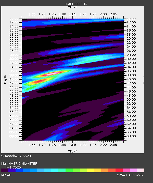
| Estimated Moho Depth: |
37.0 km |
| Estimated Crust Vp/Vs: |
1.75 |
| Assumed Crust Vp: |
6.159 km/s |
| Estimated Crust Vs: |
3.514 km/s |
| Estimated Crust Poisson's Ratio: |
0.26 |
|
| Radial Match: |
97.6523 % |
| Radial Bump: |
259 |
| Transverse Match: |
84.47636 % |
| Transverse Bump: |
400 |
| SOD ConfigId: |
61242 |
| Insert Time: |
2010-03-01 16:42:31.599 +0000 |
| GWidth: |
2.5 |
| Max Bumps: |
400 |
| Tol: |
0.001 |
|

Signal To Noise
| Channel | StoN | STA | LTA |
| II:ARU:00:BHN:19951203T18:10:04.799011Z | 18.809477 | 2.239897E-6 | 1.19083424E-7 |
| II:ARU:00:BHE:19951203T18:10:04.799011Z | 19.166199 | 4.5493416E-6 | 2.3736273E-7 |
| II:ARU:00:BHZ:19951203T18:10:04.799011Z | 26.93607 | 1.0443884E-5 | 3.8772856E-7 |
| Arrivals |
| Ps | 4.7 SECOND |
| PpPs | 16 SECOND |
| PsPs/PpSs | 20 SECOND |


