You are here: Home > Network List > TA - USArray Transportable Network (new EarthScope stations) Stations List
> Station 060Z West Palm Beach, FL, USA > Earthquake Result Viewer
060Z West Palm Beach, FL, USA - Earthquake Result Viewer
| Earthquake location: |
Northern Mid-Atlantic Ridge |
| Earthquake latitude/longitude: |
15.2/-45.2 |
| Earthquake time(UTC): |
2013/09/05 (248) 04:01:36 GMT |
| Earthquake Depth: |
10 km |
| Earthquake Magnitude: |
6.0 MWW, 5.9 MWB, 6.0 MWW, 6.0 MWC |
| Earthquake Catalog/Contributor: |
NEIC PDE/NEIC COMCAT |
|
| Network: |
TA USArray Transportable Network (new EarthScope stations) |
| Station: |
060Z West Palm Beach, FL, USA |
| Lat/Lon: |
26.41 N/80.56 W |
| Elevation: |
9.0 m |
|
| Distance: |
34.8 deg |
| Az: |
294.529 deg |
| Baz: |
101.643 deg |
| Ray Param: |
0.07758028 |
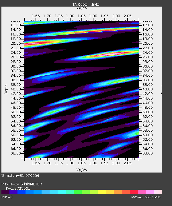
| Estimated Moho Depth: |
24.5 km |
| Estimated Crust Vp/Vs: |
1.97 |
| Assumed Crust Vp: |
6.347 km/s |
| Estimated Crust Vs: |
3.218 km/s |
| Estimated Crust Poisson's Ratio: |
0.33 |
|
| Radial Match: |
81.070656 % |
| Radial Bump: |
400 |
| Transverse Match: |
61.33503 % |
| Transverse Bump: |
400 |
| SOD ConfigId: |
626651 |
| Insert Time: |
2014-04-18 12:38:49.165 +0000 |
| GWidth: |
2.5 |
| Max Bumps: |
400 |
| Tol: |
0.001 |
|
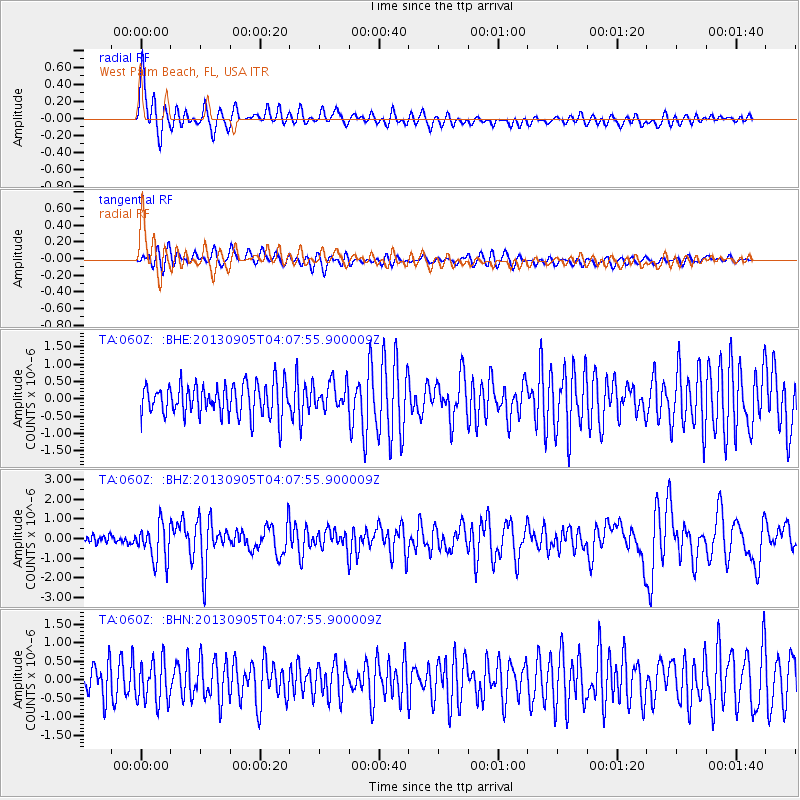
Signal To Noise
| Channel | StoN | STA | LTA |
| TA:060Z: :BHZ:20130905T04:07:55.900009Z | 3.508289 | 9.4164017E-7 | 2.684044E-7 |
| TA:060Z: :BHN:20130905T04:07:55.900009Z | 1.2487469 | 5.6392815E-7 | 4.5159527E-7 |
| TA:060Z: :BHE:20130905T04:07:55.900009Z | 0.85496336 | 3.9164772E-7 | 4.5808716E-7 |
| Arrivals |
| Ps | 4.0 SECOND |
| PpPs | 11 SECOND |
| PsPs/PpSs | 15 SECOND |


