You are here: Home > Network List > TA - USArray Transportable Network (new EarthScope stations) Stations List
> Station 154A Montrose, GA, USA > Earthquake Result Viewer
154A Montrose, GA, USA - Earthquake Result Viewer
| Earthquake location: |
Northern Mid-Atlantic Ridge |
| Earthquake latitude/longitude: |
15.2/-45.2 |
| Earthquake time(UTC): |
2013/09/05 (248) 04:01:36 GMT |
| Earthquake Depth: |
10 km |
| Earthquake Magnitude: |
6.0 MWW, 5.9 MWB, 6.0 MWW, 6.0 MWC |
| Earthquake Catalog/Contributor: |
NEIC PDE/NEIC COMCAT |
|
| Network: |
TA USArray Transportable Network (new EarthScope stations) |
| Station: |
154A Montrose, GA, USA |
| Lat/Lon: |
32.61 N/83.11 W |
| Elevation: |
111 m |
|
| Distance: |
38.5 deg |
| Az: |
303.62 deg |
| Baz: |
107.697 deg |
| Ray Param: |
0.075538464 |
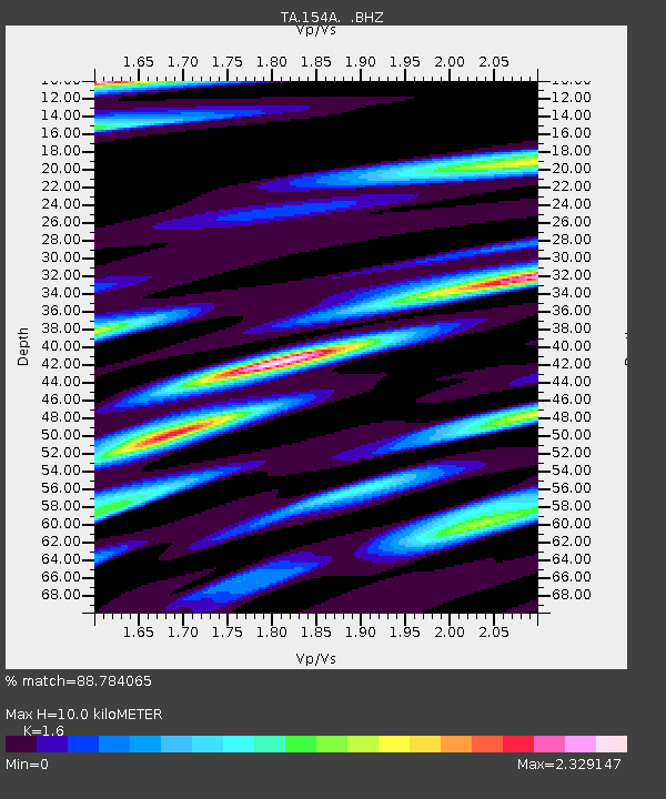
| Estimated Moho Depth: |
10.0 km |
| Estimated Crust Vp/Vs: |
1.60 |
| Assumed Crust Vp: |
6.565 km/s |
| Estimated Crust Vs: |
4.103 km/s |
| Estimated Crust Poisson's Ratio: |
0.18 |
|
| Radial Match: |
88.784065 % |
| Radial Bump: |
400 |
| Transverse Match: |
79.62075 % |
| Transverse Bump: |
400 |
| SOD ConfigId: |
626651 |
| Insert Time: |
2014-04-18 12:39:04.922 +0000 |
| GWidth: |
2.5 |
| Max Bumps: |
400 |
| Tol: |
0.001 |
|
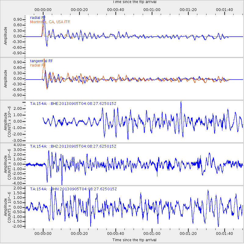
Signal To Noise
| Channel | StoN | STA | LTA |
| TA:154A: :BHZ:20130905T04:08:27.625015Z | 9.660412 | 1.5024256E-6 | 1.5552396E-7 |
| TA:154A: :BHN:20130905T04:08:27.625015Z | 2.9360282 | 8.028807E-7 | 2.734581E-7 |
| TA:154A: :BHE:20130905T04:08:27.625015Z | 3.115901 | 1.0600676E-6 | 3.402122E-7 |
| Arrivals |
| Ps | 1.0 SECOND |
| PpPs | 3.6 SECOND |
| PsPs/PpSs | 4.6 SECOND |


