You are here: Home > Network List > TA - USArray Transportable Network (new EarthScope stations) Stations List
> Station 352A Blakely, GA, USA > Earthquake Result Viewer
352A Blakely, GA, USA - Earthquake Result Viewer
| Earthquake location: |
Northern Mid-Atlantic Ridge |
| Earthquake latitude/longitude: |
15.2/-45.2 |
| Earthquake time(UTC): |
2013/09/05 (248) 04:01:36 GMT |
| Earthquake Depth: |
10 km |
| Earthquake Magnitude: |
6.0 MWW, 5.9 MWB, 6.0 MWW, 6.0 MWC |
| Earthquake Catalog/Contributor: |
NEIC PDE/NEIC COMCAT |
|
| Network: |
TA USArray Transportable Network (new EarthScope stations) |
| Station: |
352A Blakely, GA, USA |
| Lat/Lon: |
31.48 N/84.93 W |
| Elevation: |
101 m |
|
| Distance: |
39.6 deg |
| Az: |
301.21 deg |
| Baz: |
104.864 deg |
| Ray Param: |
0.07486405 |
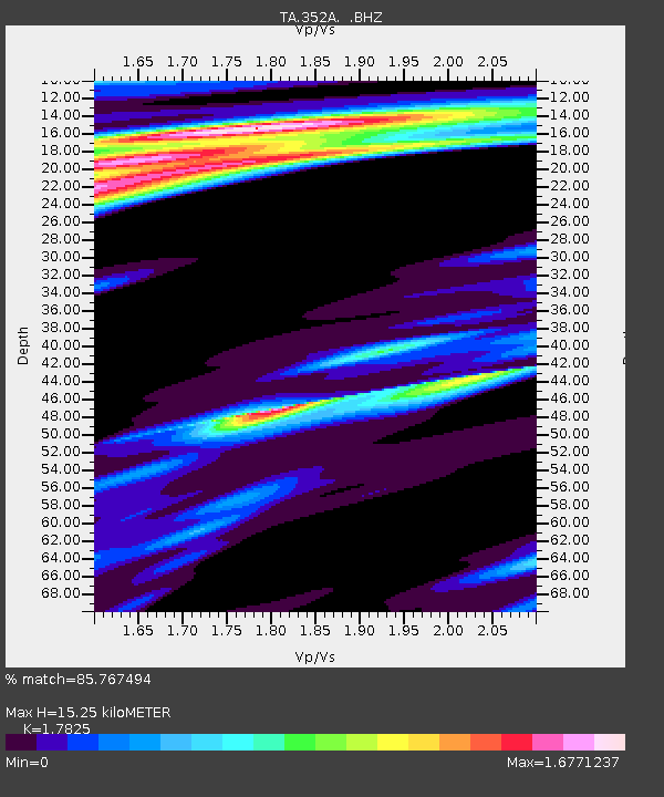
| Estimated Moho Depth: |
15.25 km |
| Estimated Crust Vp/Vs: |
1.78 |
| Assumed Crust Vp: |
6.347 km/s |
| Estimated Crust Vs: |
3.561 km/s |
| Estimated Crust Poisson's Ratio: |
0.27 |
|
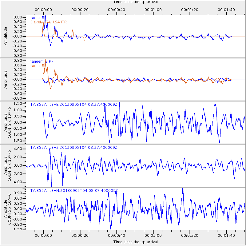
| Radial Match: |
85.767494 % |
| Radial Bump: |
294 |
| Transverse Match: |
54.46199 % |
| Transverse Bump: |
380 |
| SOD ConfigId: |
626651 |
| Insert Time: |
2014-04-18 12:39:37.256 +0000 |
| GWidth: |
2.5 |
| Max Bumps: |
400 |
| Tol: |
0.001 |
|
Signal To Noise
| Channel | StoN | STA | LTA |
| TA:352A: :BHZ:20130905T04:08:37.400009Z | 12.181005 | 2.1443686E-6 | 1.7604202E-7 |
| TA:352A: :BHN:20130905T04:08:37.400009Z | 0.94659585 | 2.3476069E-7 | 2.480052E-7 |
| TA:352A: :BHE:20130905T04:08:37.400009Z | 1.228211 | 5.604254E-7 | 4.5629406E-7 |
| Arrivals |
| Ps | 2.0 SECOND |
| PpPs | 6.2 SECOND |
| PsPs/PpSs | 8.3 SECOND |


