You are here: Home > Network List > TA - USArray Transportable Network (new EarthScope stations) Stations List
> Station 456A Hilliard, FL, USA > Earthquake Result Viewer
456A Hilliard, FL, USA - Earthquake Result Viewer
| Earthquake location: |
Northern Mid-Atlantic Ridge |
| Earthquake latitude/longitude: |
15.2/-45.2 |
| Earthquake time(UTC): |
2013/09/05 (248) 04:01:36 GMT |
| Earthquake Depth: |
10 km |
| Earthquake Magnitude: |
6.0 MWW, 5.9 MWB, 6.0 MWW, 6.0 MWC |
| Earthquake Catalog/Contributor: |
NEIC PDE/NEIC COMCAT |
|
| Network: |
TA USArray Transportable Network (new EarthScope stations) |
| Station: |
456A Hilliard, FL, USA |
| Lat/Lon: |
30.72 N/82.02 W |
| Elevation: |
26 m |
|
| Distance: |
37.0 deg |
| Az: |
301.121 deg |
| Baz: |
106.288 deg |
| Ray Param: |
0.0763506 |
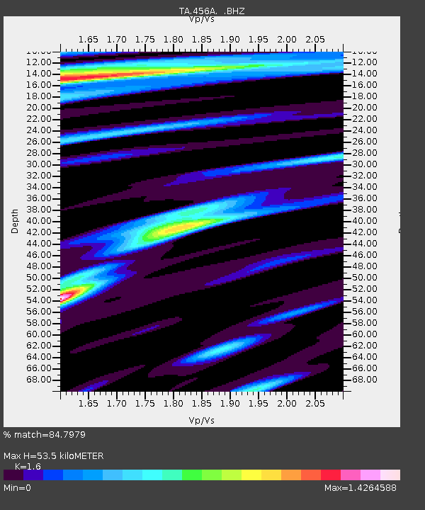
| Estimated Moho Depth: |
53.5 km |
| Estimated Crust Vp/Vs: |
1.60 |
| Assumed Crust Vp: |
6.565 km/s |
| Estimated Crust Vs: |
4.103 km/s |
| Estimated Crust Poisson's Ratio: |
0.18 |
|
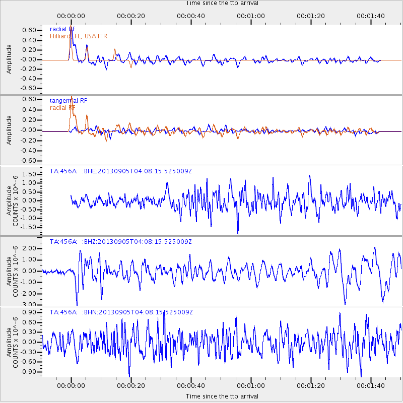
| Radial Match: |
84.7979 % |
| Radial Bump: |
400 |
| Transverse Match: |
59.773415 % |
| Transverse Bump: |
400 |
| SOD ConfigId: |
626651 |
| Insert Time: |
2014-04-18 12:40:00.455 +0000 |
| GWidth: |
2.5 |
| Max Bumps: |
400 |
| Tol: |
0.001 |
|
Signal To Noise
| Channel | StoN | STA | LTA |
| TA:456A: :BHZ:20130905T04:08:15.525009Z | 7.8816643 | 1.2280664E-6 | 1.5581307E-7 |
| TA:456A: :BHN:20130905T04:08:15.525009Z | 1.7522129 | 3.0254435E-7 | 1.7266416E-7 |
| TA:456A: :BHE:20130905T04:08:15.525009Z | 2.2033396 | 4.3374774E-7 | 1.9685923E-7 |
| Arrivals |
| Ps | 5.3 SECOND |
| PpPs | 19 SECOND |
| PsPs/PpSs | 25 SECOND |


