You are here: Home > Network List > II - Global Seismograph Network (GSN - IRIS/IDA) Stations List
> Station ARU Arti, Russia > Earthquake Result Viewer
ARU Arti, Russia - Earthquake Result Viewer
| Earthquake location: |
Kuril Islands |
| Earthquake latitude/longitude: |
44.1/148.1 |
| Earthquake time(UTC): |
1995/04/28 (118) 16:30:00 GMT |
| Earthquake Depth: |
29 km |
| Earthquake Magnitude: |
6.6 MB, 6.9 MS, 7.0 UNKNOWN, 6.8 MW |
| Earthquake Catalog/Contributor: |
WHDF/NEIC |
|
| Network: |
II Global Seismograph Network (GSN - IRIS/IDA) |
| Station: |
ARU Arti, Russia |
| Lat/Lon: |
56.43 N/58.56 E |
| Elevation: |
250 m |
|
| Distance: |
54.6 deg |
| Az: |
317.017 deg |
| Baz: |
62.228 deg |
| Ray Param: |
0.065320365 |
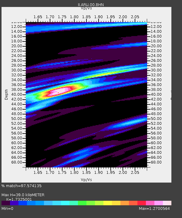
| Estimated Moho Depth: |
39.0 km |
| Estimated Crust Vp/Vs: |
1.73 |
| Assumed Crust Vp: |
6.159 km/s |
| Estimated Crust Vs: |
3.555 km/s |
| Estimated Crust Poisson's Ratio: |
0.25 |
|
| Radial Match: |
97.574135 % |
| Radial Bump: |
293 |
| Transverse Match: |
81.66596 % |
| Transverse Bump: |
400 |
| SOD ConfigId: |
61242 |
| Insert Time: |
2010-03-01 16:42:40.323 +0000 |
| GWidth: |
2.5 |
| Max Bumps: |
400 |
| Tol: |
0.001 |
|
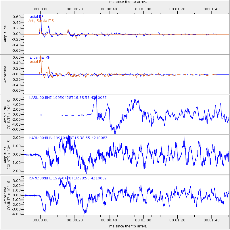
Signal To Noise
| Channel | StoN | STA | LTA |
| II:ARU:00:BHN:19950428T16:38:55.421008Z | 15.653338 | 8.8952174E-7 | 5.682633E-8 |
| II:ARU:00:BHE:19950428T16:38:55.421008Z | 19.40584 | 1.8215694E-6 | 9.386707E-8 |
| II:ARU:00:BHZ:19950428T16:38:55.421008Z | 98.46492 | 3.9175175E-6 | 3.978592E-8 |
| Arrivals |
| Ps | 4.9 SECOND |
| PpPs | 16 SECOND |
| PsPs/PpSs | 21 SECOND |


