You are here: Home > Network List > TA - USArray Transportable Network (new EarthScope stations) Stations List
> Station F52A Sundridge, ON, CAN > Earthquake Result Viewer
F52A Sundridge, ON, CAN - Earthquake Result Viewer
| Earthquake location: |
Northern Mid-Atlantic Ridge |
| Earthquake latitude/longitude: |
15.2/-45.2 |
| Earthquake time(UTC): |
2013/09/05 (248) 04:01:36 GMT |
| Earthquake Depth: |
10 km |
| Earthquake Magnitude: |
6.0 MWW, 5.9 MWB, 6.0 MWW, 6.0 MWC |
| Earthquake Catalog/Contributor: |
NEIC PDE/NEIC COMCAT |
|
| Network: |
TA USArray Transportable Network (new EarthScope stations) |
| Station: |
F52A Sundridge, ON, CAN |
| Lat/Lon: |
45.80 N/79.32 W |
| Elevation: |
351 m |
|
| Distance: |
41.8 deg |
| Az: |
323.966 deg |
| Baz: |
125.724 deg |
| Ray Param: |
0.07355835 |
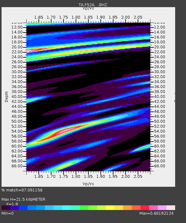
| Estimated Moho Depth: |
21.5 km |
| Estimated Crust Vp/Vs: |
1.60 |
| Assumed Crust Vp: |
6.577 km/s |
| Estimated Crust Vs: |
4.111 km/s |
| Estimated Crust Poisson's Ratio: |
0.18 |
|
| Radial Match: |
87.091156 % |
| Radial Bump: |
378 |
| Transverse Match: |
66.85377 % |
| Transverse Bump: |
400 |
| SOD ConfigId: |
626651 |
| Insert Time: |
2014-04-18 12:42:27.878 +0000 |
| GWidth: |
2.5 |
| Max Bumps: |
400 |
| Tol: |
0.001 |
|
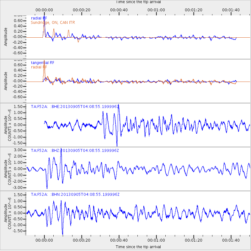
Signal To Noise
| Channel | StoN | STA | LTA |
| TA:F52A: :BHZ:20130905T04:08:55.199996Z | 5.1319923 | 1.2445017E-6 | 2.4249874E-7 |
| TA:F52A: :BHN:20130905T04:08:55.199996Z | 3.5572293 | 5.002799E-7 | 1.4063752E-7 |
| TA:F52A: :BHE:20130905T04:08:55.199996Z | 3.1581304 | 5.821636E-7 | 1.8433805E-7 |
| Arrivals |
| Ps | 2.1 SECOND |
| PpPs | 7.8 SECOND |
| PsPs/PpSs | 10.0 SECOND |


