You are here: Home > Network List > TA - USArray Transportable Network (new EarthScope stations) Stations List
> Station G39A Holcombe, WI, USA > Earthquake Result Viewer
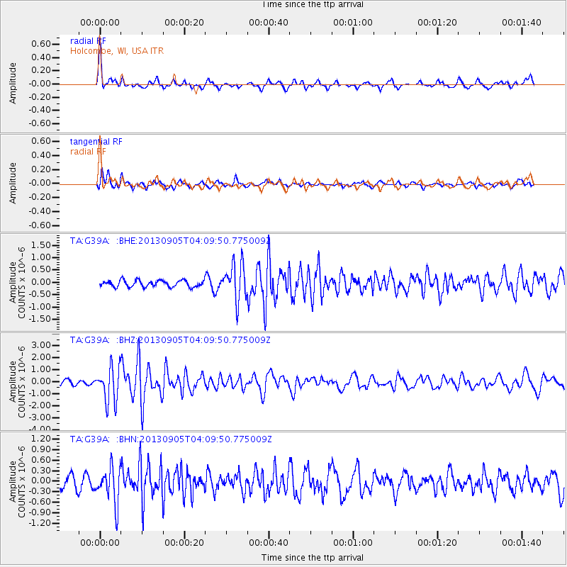
G39A Holcombe, WI, USA - Earthquake Result Viewer
*The percent match for this event was below the threshold and hence no stack was calculated.
| Earthquake location: |
Northern Mid-Atlantic Ridge |
| Earthquake latitude/longitude: |
15.2/-45.2 |
| Earthquake time(UTC): |
2013/09/05 (248) 04:01:36 GMT |
| Earthquake Depth: |
10 km |
| Earthquake Magnitude: |
6.0 MWW, 5.9 MWB, 6.0 MWW, 6.0 MWC |
| Earthquake Catalog/Contributor: |
NEIC PDE/NEIC COMCAT |
|
| Network: |
TA USArray Transportable Network (new EarthScope stations) |
| Station: |
G39A Holcombe, WI, USA |
| Lat/Lon: |
45.29 N/91.17 W |
| Elevation: |
350 m |
|
| Distance: |
48.8 deg |
| Az: |
317.627 deg |
| Baz: |
112.813 deg |
| Ray Param: |
$rayparam |
*The percent match for this event was below the threshold and hence was not used in the summary stack. |
|
| Radial Match: |
79.97743 % |
| Radial Bump: |
301 |
| Transverse Match: |
79.49257 % |
| Transverse Bump: |
400 |
| SOD ConfigId: |
626651 |
| Insert Time: |
2014-04-18 12:42:48.609 +0000 |
| GWidth: |
2.5 |
| Max Bumps: |
400 |
| Tol: |
0.001 |
|
Signal To Noise
| Channel | StoN | STA | LTA |
| TA:G39A: :BHZ:20130905T04:09:50.775009Z | 8.992355 | 1.4769556E-6 | 1.6424568E-7 |
| TA:G39A: :BHN:20130905T04:09:50.775009Z | 3.447574 | 5.242934E-7 | 1.5207604E-7 |
| TA:G39A: :BHE:20130905T04:09:50.775009Z | 5.7390046 | 7.5549184E-7 | 1.3164161E-7 |
| Arrivals |
| Ps | |
| PpPs | |
| PsPs/PpSs | |


