You are here: Home > Network List > TA - USArray Transportable Network (new EarthScope stations) Stations List
> Station G57A Newington, ON, CAN > Earthquake Result Viewer
G57A Newington, ON, CAN - Earthquake Result Viewer
| Earthquake location: |
Northern Mid-Atlantic Ridge |
| Earthquake latitude/longitude: |
15.2/-45.2 |
| Earthquake time(UTC): |
2013/09/05 (248) 04:01:36 GMT |
| Earthquake Depth: |
10 km |
| Earthquake Magnitude: |
6.0 MWW, 5.9 MWB, 6.0 MWW, 6.0 MWC |
| Earthquake Catalog/Contributor: |
NEIC PDE/NEIC COMCAT |
|
| Network: |
TA USArray Transportable Network (new EarthScope stations) |
| Station: |
G57A Newington, ON, CAN |
| Lat/Lon: |
45.10 N/74.99 W |
| Elevation: |
96 m |
|
| Distance: |
39.0 deg |
| Az: |
326.03 deg |
| Baz: |
130.378 deg |
| Ray Param: |
0.075250976 |
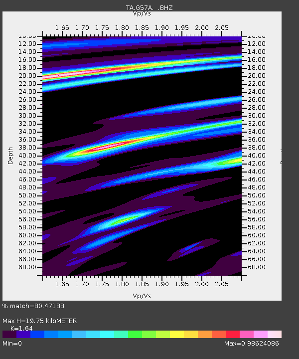
| Estimated Moho Depth: |
19.75 km |
| Estimated Crust Vp/Vs: |
1.64 |
| Assumed Crust Vp: |
6.419 km/s |
| Estimated Crust Vs: |
3.914 km/s |
| Estimated Crust Poisson's Ratio: |
0.20 |
|
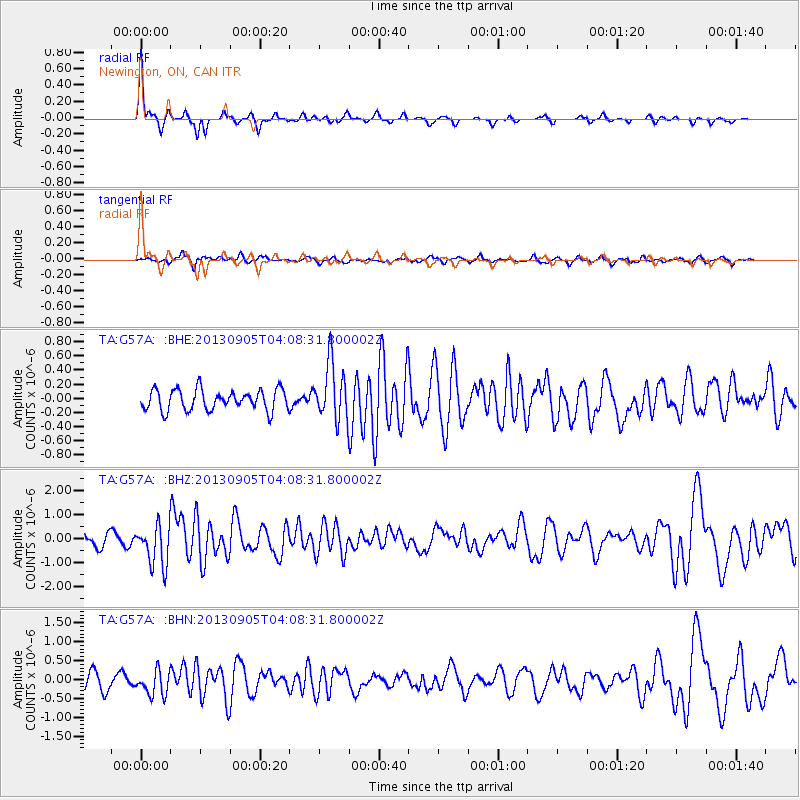
| Radial Match: |
80.47188 % |
| Radial Bump: |
199 |
| Transverse Match: |
66.026306 % |
| Transverse Bump: |
400 |
| SOD ConfigId: |
626651 |
| Insert Time: |
2014-04-18 12:43:08.322 +0000 |
| GWidth: |
2.5 |
| Max Bumps: |
400 |
| Tol: |
0.001 |
|
Signal To Noise
| Channel | StoN | STA | LTA |
| TA:G57A: :BHZ:20130905T04:08:31.800002Z | 4.5621133 | 8.6165994E-7 | 1.8887297E-7 |
| TA:G57A: :BHN:20130905T04:08:31.800002Z | 1.9184693 | 3.2552083E-7 | 1.6967738E-7 |
| TA:G57A: :BHE:20130905T04:08:31.800002Z | 2.7253609 | 3.9641358E-7 | 1.4545361E-7 |
| Arrivals |
| Ps | 2.1 SECOND |
| PpPs | 7.5 SECOND |
| PsPs/PpSs | 9.6 SECOND |


