You are here: Home > Network List > TA - USArray Transportable Network (new EarthScope stations) Stations List
> Station H56A Elgin, ON, CAN > Earthquake Result Viewer
H56A Elgin, ON, CAN - Earthquake Result Viewer
| Earthquake location: |
Northern Mid-Atlantic Ridge |
| Earthquake latitude/longitude: |
15.2/-45.2 |
| Earthquake time(UTC): |
2013/09/05 (248) 04:01:36 GMT |
| Earthquake Depth: |
10 km |
| Earthquake Magnitude: |
6.0 MWW, 5.9 MWB, 6.0 MWW, 6.0 MWC |
| Earthquake Catalog/Contributor: |
NEIC PDE/NEIC COMCAT |
|
| Network: |
TA USArray Transportable Network (new EarthScope stations) |
| Station: |
H56A Elgin, ON, CAN |
| Lat/Lon: |
44.59 N/76.26 W |
| Elevation: |
137 m |
|
| Distance: |
39.4 deg |
| Az: |
324.495 deg |
| Baz: |
128.292 deg |
| Ray Param: |
0.07503304 |
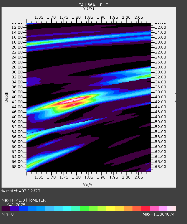
| Estimated Moho Depth: |
41.0 km |
| Estimated Crust Vp/Vs: |
1.79 |
| Assumed Crust Vp: |
6.577 km/s |
| Estimated Crust Vs: |
3.679 km/s |
| Estimated Crust Poisson's Ratio: |
0.27 |
|
| Radial Match: |
87.12673 % |
| Radial Bump: |
312 |
| Transverse Match: |
55.08618 % |
| Transverse Bump: |
316 |
| SOD ConfigId: |
626651 |
| Insert Time: |
2014-04-18 12:43:39.447 +0000 |
| GWidth: |
2.5 |
| Max Bumps: |
400 |
| Tol: |
0.001 |
|

Signal To Noise
| Channel | StoN | STA | LTA |
| TA:H56A: :BHZ:20130905T04:08:34.949996Z | 6.3653946 | 1.4530552E-6 | 2.2827419E-7 |
| TA:H56A: :BHN:20130905T04:08:34.949996Z | 2.5663104 | 5.501178E-7 | 2.1436138E-7 |
| TA:H56A: :BHE:20130905T04:08:34.949996Z | 5.021248 | 6.869193E-7 | 1.3680251E-7 |
| Arrivals |
| Ps | 5.3 SECOND |
| PpPs | 16 SECOND |
| PsPs/PpSs | 21 SECOND |


