You are here: Home > Network List > TA - USArray Transportable Network (new EarthScope stations) Stations List
> Station I41A Arkdale, WI, USA > Earthquake Result Viewer
I41A Arkdale, WI, USA - Earthquake Result Viewer

| Earthquake location: |
Northern Mid-Atlantic Ridge |
| Earthquake latitude/longitude: |
15.2/-45.2 |
| Earthquake time(UTC): |
2013/09/05 (248) 04:01:36 GMT |
| Earthquake Depth: |
10 km |
| Earthquake Magnitude: |
6.0 MWW, 5.9 MWB, 6.0 MWW, 6.0 MWC |
| Earthquake Catalog/Contributor: |
NEIC PDE/NEIC COMCAT |
|
| Network: |
TA USArray Transportable Network (new EarthScope stations) |
| Station: |
I41A Arkdale, WI, USA |
| Lat/Lon: |
44.06 N/89.87 W |
| Elevation: |
289 m |
|
| Distance: |
47.5 deg |
| Az: |
316.595 deg |
| Baz: |
113.035 deg |
| Ray Param: |
0.06995371 |
| Estimated Moho Depth: |
62.5 km |
| Estimated Crust Vp/Vs: |
1.73 |
| Assumed Crust Vp: |
6.41 km/s |
| Estimated Crust Vs: |
3.7 km/s |
| Estimated Crust Poisson's Ratio: |
0.25 |
|
| Radial Match: |
86.21484 % |
| Radial Bump: |
400 |
| Transverse Match: |
65.16978 % |
| Transverse Bump: |
400 |
| SOD ConfigId: |
626651 |
| Insert Time: |
2014-04-18 12:44:02.205 +0000 |
| GWidth: |
2.5 |
| Max Bumps: |
400 |
| Tol: |
0.001 |
|
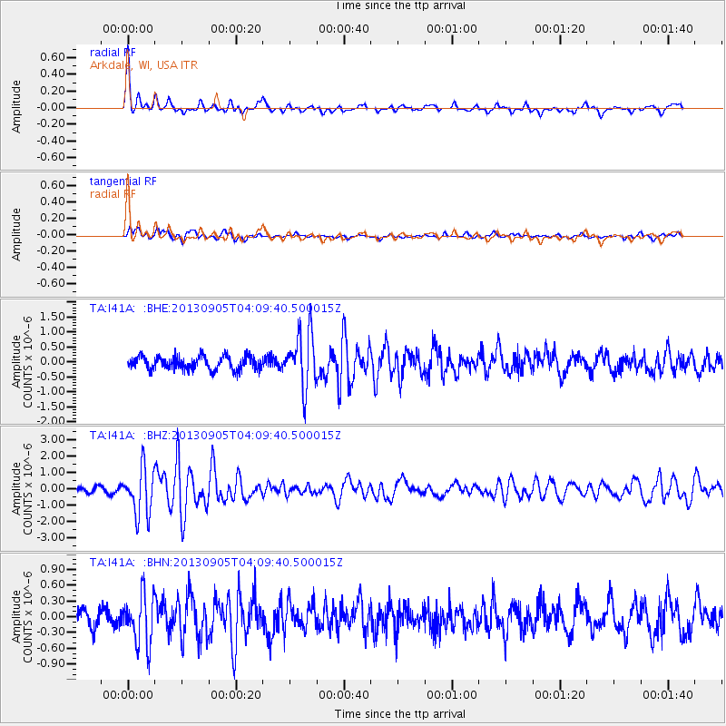
Signal To Noise
| Channel | StoN | STA | LTA |
| TA:I41A: :BHZ:20130905T04:09:40.500015Z | 7.4289503 | 1.4165064E-6 | 1.9067383E-7 |
| TA:I41A: :BHN:20130905T04:09:40.500015Z | 2.1162407 | 4.7153958E-7 | 2.2281945E-7 |
| TA:I41A: :BHE:20130905T04:09:40.500015Z | 4.1550555 | 9.2381646E-7 | 2.2233554E-7 |
| Arrivals |
| Ps | 7.6 SECOND |
| PpPs | 25 SECOND |
| PsPs/PpSs | 33 SECOND |


