You are here: Home > Network List > TA - USArray Transportable Network (new EarthScope stations) Stations List
> Station I47A Gladwin, MI, USA > Earthquake Result Viewer
I47A Gladwin, MI, USA - Earthquake Result Viewer

| Earthquake location: |
Northern Mid-Atlantic Ridge |
| Earthquake latitude/longitude: |
15.2/-45.2 |
| Earthquake time(UTC): |
2013/09/05 (248) 04:01:36 GMT |
| Earthquake Depth: |
10 km |
| Earthquake Magnitude: |
6.0 MWW, 5.9 MWB, 6.0 MWW, 6.0 MWC |
| Earthquake Catalog/Contributor: |
NEIC PDE/NEIC COMCAT |
|
| Network: |
TA USArray Transportable Network (new EarthScope stations) |
| Station: |
I47A Gladwin, MI, USA |
| Lat/Lon: |
44.02 N/84.51 W |
| Elevation: |
269 m |
|
| Distance: |
44.0 deg |
| Az: |
318.884 deg |
| Baz: |
118.348 deg |
| Ray Param: |
0.07219159 |
| Estimated Moho Depth: |
19.0 km |
| Estimated Crust Vp/Vs: |
1.66 |
| Assumed Crust Vp: |
6.483 km/s |
| Estimated Crust Vs: |
3.899 km/s |
| Estimated Crust Poisson's Ratio: |
0.22 |
|
| Radial Match: |
87.407234 % |
| Radial Bump: |
400 |
| Transverse Match: |
72.41334 % |
| Transverse Bump: |
400 |
| SOD ConfigId: |
626651 |
| Insert Time: |
2014-04-18 12:44:12.410 +0000 |
| GWidth: |
2.5 |
| Max Bumps: |
400 |
| Tol: |
0.001 |
|
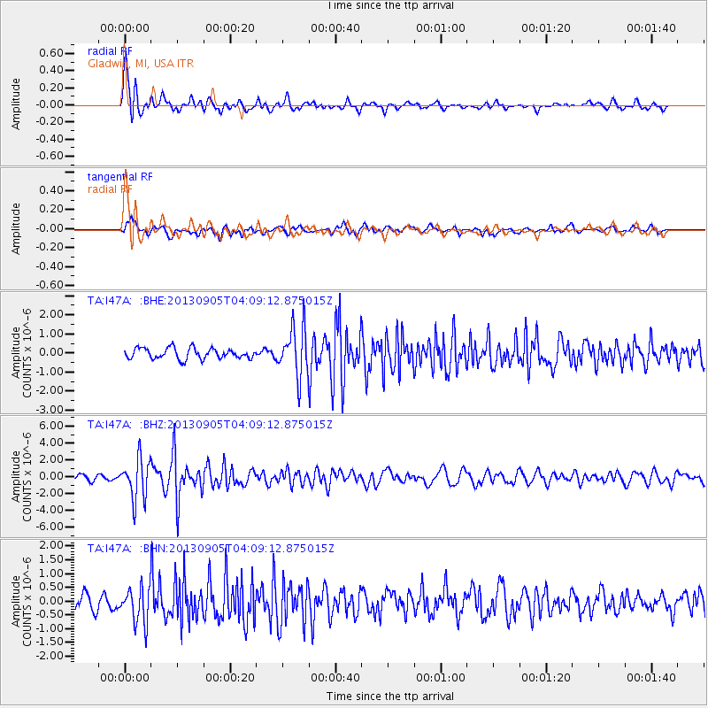
Signal To Noise
| Channel | StoN | STA | LTA |
| TA:I47A: :BHZ:20130905T04:09:12.875015Z | 7.8596983 | 2.4148083E-6 | 3.072393E-7 |
| TA:I47A: :BHN:20130905T04:09:12.875015Z | 1.974435 | 6.4969544E-7 | 3.2905385E-7 |
| TA:I47A: :BHE:20130905T04:09:12.875015Z | 4.646452 | 1.2984584E-6 | 2.794516E-7 |
| Arrivals |
| Ps | 2.1 SECOND |
| PpPs | 7.3 SECOND |
| PsPs/PpSs | 9.4 SECOND |


