You are here: Home > Network List > TA - USArray Transportable Network (new EarthScope stations) Stations List
> Station I51A Listowel, ON, CAN > Earthquake Result Viewer
I51A Listowel, ON, CAN - Earthquake Result Viewer
| Earthquake location: |
Northern Mid-Atlantic Ridge |
| Earthquake latitude/longitude: |
15.2/-45.2 |
| Earthquake time(UTC): |
2013/09/05 (248) 04:01:36 GMT |
| Earthquake Depth: |
10 km |
| Earthquake Magnitude: |
6.0 MWW, 5.9 MWB, 6.0 MWW, 6.0 MWC |
| Earthquake Catalog/Contributor: |
NEIC PDE/NEIC COMCAT |
|
| Network: |
TA USArray Transportable Network (new EarthScope stations) |
| Station: |
I51A Listowel, ON, CAN |
| Lat/Lon: |
43.80 N/81.02 W |
| Elevation: |
376 m |
|
| Distance: |
41.7 deg |
| Az: |
320.47 deg |
| Baz: |
121.921 deg |
| Ray Param: |
0.073624134 |
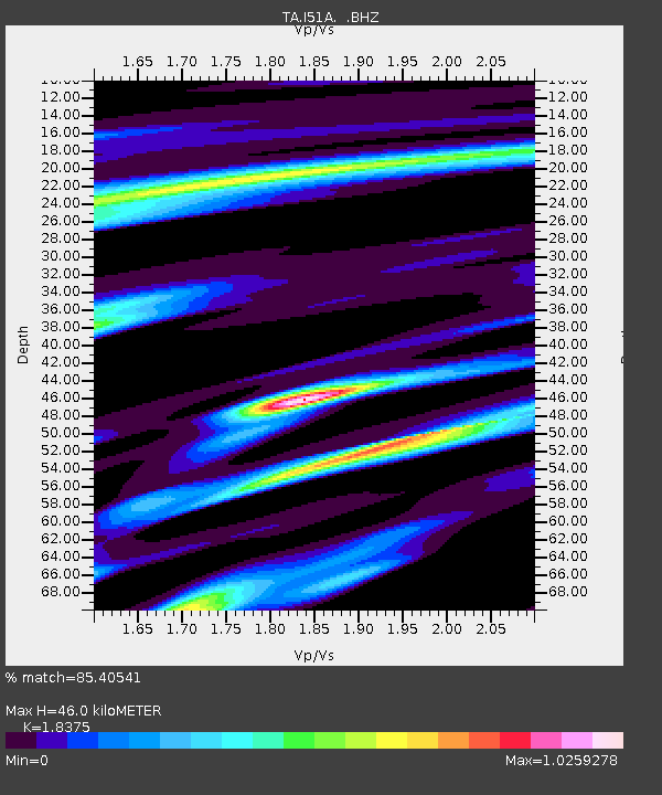
| Estimated Moho Depth: |
46.0 km |
| Estimated Crust Vp/Vs: |
1.84 |
| Assumed Crust Vp: |
6.53 km/s |
| Estimated Crust Vs: |
3.554 km/s |
| Estimated Crust Poisson's Ratio: |
0.29 |
|
| Radial Match: |
85.40541 % |
| Radial Bump: |
355 |
| Transverse Match: |
64.698524 % |
| Transverse Bump: |
400 |
| SOD ConfigId: |
626651 |
| Insert Time: |
2014-04-18 12:44:19.236 +0000 |
| GWidth: |
2.5 |
| Max Bumps: |
400 |
| Tol: |
0.001 |
|
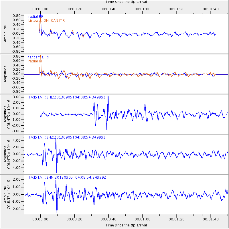
Signal To Noise
| Channel | StoN | STA | LTA |
| TA:I51A: :BHZ:20130905T04:08:54.34999Z | 8.053258 | 1.6755544E-6 | 2.0805919E-7 |
| TA:I51A: :BHN:20130905T04:08:54.34999Z | 4.422999 | 7.310205E-7 | 1.6527713E-7 |
| TA:I51A: :BHE:20130905T04:08:54.34999Z | 7.1231813 | 1.017556E-6 | 1.4285133E-7 |
| Arrivals |
| Ps | 6.3 SECOND |
| PpPs | 19 SECOND |
| PsPs/PpSs | 25 SECOND |


