You are here: Home > Network List > II - Global Seismograph Network (GSN - IRIS/IDA) Stations List
> Station ARU Arti, Russia > Earthquake Result Viewer
ARU Arti, Russia - Earthquake Result Viewer
| Earthquake location: |
Samar, Philippines |
| Earthquake latitude/longitude: |
12.0/125.7 |
| Earthquake time(UTC): |
1995/04/21 (111) 00:09:56 GMT |
| Earthquake Depth: |
33 km |
| Earthquake Magnitude: |
6.1 MB, 6.9 MS, 6.9 UNKNOWN, 6.8 MW |
| Earthquake Catalog/Contributor: |
WHDF/NEIC |
|
| Network: |
II Global Seismograph Network (GSN - IRIS/IDA) |
| Station: |
ARU Arti, Russia |
| Lat/Lon: |
56.43 N/58.56 E |
| Elevation: |
250 m |
|
| Distance: |
67.5 deg |
| Az: |
326.349 deg |
| Baz: |
102.589 deg |
| Ray Param: |
0.056875423 |
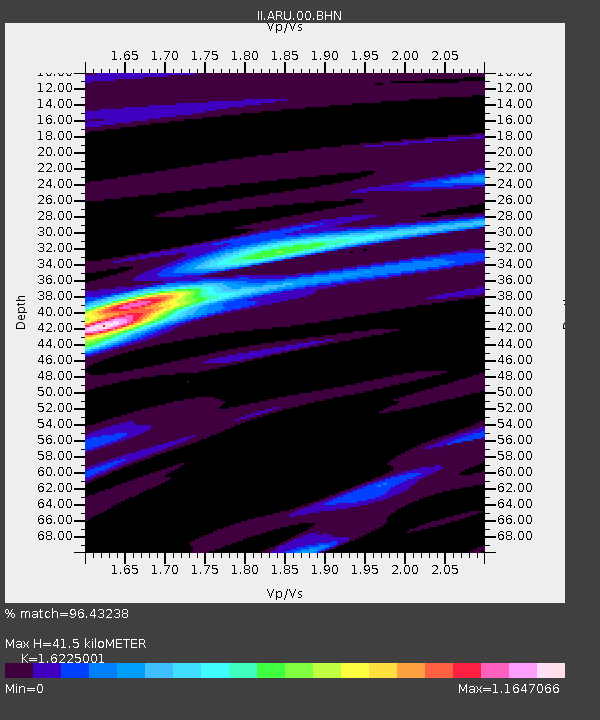
| Estimated Moho Depth: |
41.5 km |
| Estimated Crust Vp/Vs: |
1.62 |
| Assumed Crust Vp: |
6.159 km/s |
| Estimated Crust Vs: |
3.796 km/s |
| Estimated Crust Poisson's Ratio: |
0.19 |
|
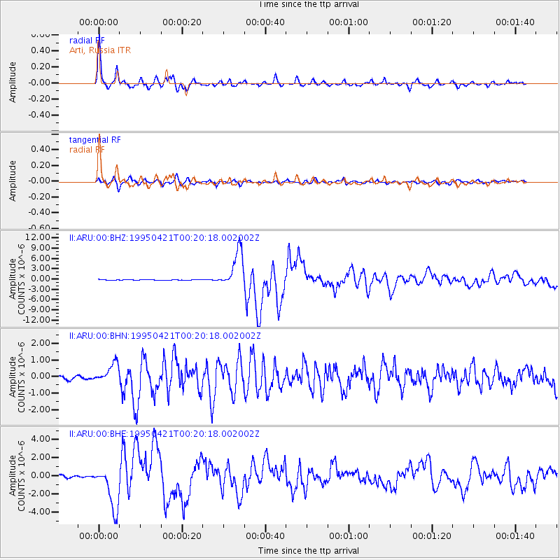
| Radial Match: |
96.43238 % |
| Radial Bump: |
373 |
| Transverse Match: |
91.17693 % |
| Transverse Bump: |
400 |
| SOD ConfigId: |
61242 |
| Insert Time: |
2010-03-01 16:42:57.868 +0000 |
| GWidth: |
2.5 |
| Max Bumps: |
400 |
| Tol: |
0.001 |
|
Signal To Noise
| Channel | StoN | STA | LTA |
| II:ARU:00:BHN:19950421T00:20:18.002002Z | 6.7106247 | 6.1807685E-7 | 9.2104216E-8 |
| II:ARU:00:BHE:19950421T00:20:18.002002Z | 22.03188 | 2.526582E-6 | 1.14678464E-7 |
| II:ARU:00:BHZ:19950421T00:20:18.002002Z | 65.14308 | 5.5802675E-6 | 8.56617E-8 |
| Arrivals |
| Ps | 4.4 SECOND |
| PpPs | 17 SECOND |
| PsPs/PpSs | 21 SECOND |


