You are here: Home > Network List > TA - USArray Transportable Network (new EarthScope stations) Stations List
> Station L42A Oliver, Polo, IL, USA > Earthquake Result Viewer
L42A Oliver, Polo, IL, USA - Earthquake Result Viewer
| Earthquake location: |
Northern Mid-Atlantic Ridge |
| Earthquake latitude/longitude: |
15.2/-45.2 |
| Earthquake time(UTC): |
2013/09/05 (248) 04:01:36 GMT |
| Earthquake Depth: |
10 km |
| Earthquake Magnitude: |
6.0 MWW, 5.9 MWB, 6.0 MWW, 6.0 MWC |
| Earthquake Catalog/Contributor: |
NEIC PDE/NEIC COMCAT |
|
| Network: |
TA USArray Transportable Network (new EarthScope stations) |
| Station: |
L42A Oliver, Polo, IL, USA |
| Lat/Lon: |
42.00 N/89.67 W |
| Elevation: |
257 m |
|
| Distance: |
46.6 deg |
| Az: |
314.074 deg |
| Baz: |
111.454 deg |
| Ray Param: |
0.07055824 |
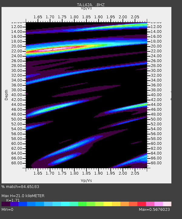
| Estimated Moho Depth: |
21.0 km |
| Estimated Crust Vp/Vs: |
1.71 |
| Assumed Crust Vp: |
6.571 km/s |
| Estimated Crust Vs: |
3.842 km/s |
| Estimated Crust Poisson's Ratio: |
0.24 |
|
| Radial Match: |
84.65183 % |
| Radial Bump: |
400 |
| Transverse Match: |
60.37779 % |
| Transverse Bump: |
400 |
| SOD ConfigId: |
626651 |
| Insert Time: |
2014-04-18 12:46:07.577 +0000 |
| GWidth: |
2.5 |
| Max Bumps: |
400 |
| Tol: |
0.001 |
|
Signal To Noise
| Channel | StoN | STA | LTA |
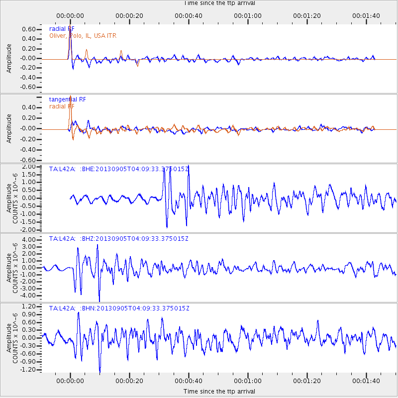
| TA:L42A: :BHZ:20130905T04:09:33.375015Z | 7.7987447 | 1.6499441E-6 | 2.1156534E-7 |
| TA:L42A: :BHN:20130905T04:09:33.375015Z | 2.727524 | 4.519318E-7 | 1.6569307E-7 |
| TA:L42A: :BHE:20130905T04:09:33.375015Z | 6.138116 | 9.758886E-7 | 1.589883E-7 |
| Arrivals |
| Ps | 2.4 SECOND |
| PpPs | 8.1 SECOND |
| PsPs/PpSs | 11 SECOND |


