You are here: Home > Network List > TA - USArray Transportable Network (new EarthScope stations) Stations List
> Station L57A Andrews Acres Farm, Gillet, PA, USA > Earthquake Result Viewer
L57A Andrews Acres Farm, Gillet, PA, USA - Earthquake Result Viewer
| Earthquake location: |
Northern Mid-Atlantic Ridge |
| Earthquake latitude/longitude: |
15.2/-45.2 |
| Earthquake time(UTC): |
2013/09/05 (248) 04:01:36 GMT |
| Earthquake Depth: |
10 km |
| Earthquake Magnitude: |
6.0 MWW, 5.9 MWB, 6.0 MWW, 6.0 MWC |
| Earthquake Catalog/Contributor: |
NEIC PDE/NEIC COMCAT |
|
| Network: |
TA USArray Transportable Network (new EarthScope stations) |
| Station: |
L57A Andrews Acres Farm, Gillet, PA, USA |
| Lat/Lon: |
42.00 N/76.85 W |
| Elevation: |
546 m |
|
| Distance: |
38.2 deg |
| Az: |
320.762 deg |
| Baz: |
124.978 deg |
| Ray Param: |
0.07572692 |
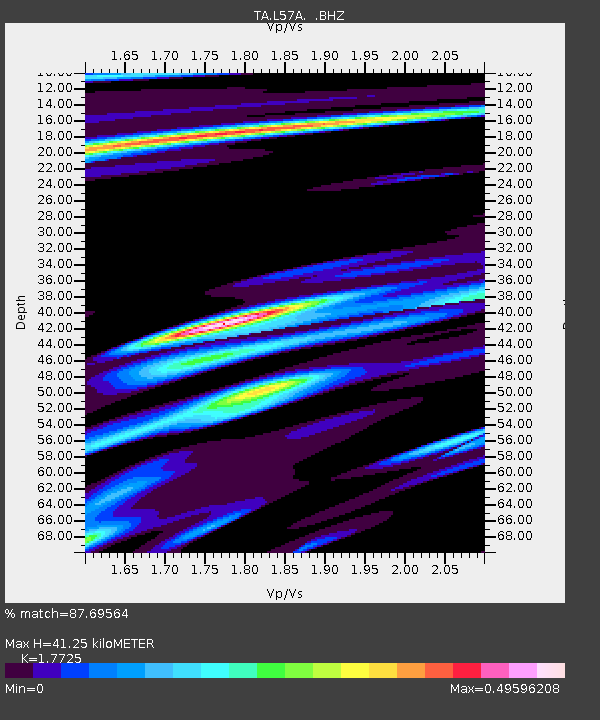
| Estimated Moho Depth: |
41.25 km |
| Estimated Crust Vp/Vs: |
1.77 |
| Assumed Crust Vp: |
6.476 km/s |
| Estimated Crust Vs: |
3.654 km/s |
| Estimated Crust Poisson's Ratio: |
0.27 |
|
| Radial Match: |
87.69564 % |
| Radial Bump: |
325 |
| Transverse Match: |
65.513306 % |
| Transverse Bump: |
400 |
| SOD ConfigId: |
626651 |
| Insert Time: |
2014-04-18 12:46:32.025 +0000 |
| GWidth: |
2.5 |
| Max Bumps: |
400 |
| Tol: |
0.001 |
|

Signal To Noise
| Channel | StoN | STA | LTA |
| TA:L57A: :BHZ:20130905T04:08:24.875015Z | 6.302607 | 1.8875605E-6 | 2.9948885E-7 |
| TA:L57A: :BHN:20130905T04:08:24.875015Z | 3.2684538 | 6.813111E-7 | 2.084506E-7 |
| TA:L57A: :BHE:20130905T04:08:24.875015Z | 6.8800983 | 7.445625E-7 | 1.08219744E-7 |
| Arrivals |
| Ps | 5.3 SECOND |
| PpPs | 16 SECOND |
| PsPs/PpSs | 22 SECOND |


