You are here: Home > Network List > TA - USArray Transportable Network (new EarthScope stations) Stations List
> Station M58A Price's Panorama, Nuncy Valley, PA, USA > Earthquake Result Viewer
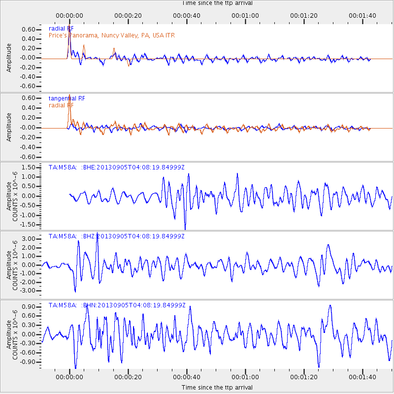
M58A Price's Panorama, Nuncy Valley, PA, USA - Earthquake Result Viewer

| Earthquake location: |
Northern Mid-Atlantic Ridge |
| Earthquake latitude/longitude: |
15.2/-45.2 |
| Earthquake time(UTC): |
2013/09/05 (248) 04:01:36 GMT |
| Earthquake Depth: |
10 km |
| Earthquake Magnitude: |
6.0 MWW, 5.9 MWB, 6.0 MWW, 6.0 MWC |
| Earthquake Catalog/Contributor: |
NEIC PDE/NEIC COMCAT |
|
| Network: |
TA USArray Transportable Network (new EarthScope stations) |
| Station: |
M58A Price's Panorama, Nuncy Valley, PA, USA |
| Lat/Lon: |
41.37 N/76.46 W |
| Elevation: |
529 m |
|
| Distance: |
37.6 deg |
| Az: |
320.194 deg |
| Baz: |
124.787 deg |
| Ray Param: |
0.07607258 |
| Estimated Moho Depth: |
21.25 km |
| Estimated Crust Vp/Vs: |
1.75 |
| Assumed Crust Vp: |
6.121 km/s |
| Estimated Crust Vs: |
3.502 km/s |
| Estimated Crust Poisson's Ratio: |
0.26 |
|
| Radial Match: |
80.09882 % |
| Radial Bump: |
400 |
| Transverse Match: |
59.800255 % |
| Transverse Bump: |
400 |
| SOD ConfigId: |
626651 |
| Insert Time: |
2014-04-18 12:47:21.228 +0000 |
| GWidth: |
2.5 |
| Max Bumps: |
400 |
| Tol: |
0.001 |
|
Signal To Noise
| Channel | StoN | STA | LTA |
| TA:M58A: :BHZ:20130905T04:08:19.84999Z | 4.6048803 | 1.4282848E-6 | 3.1016762E-7 |
| TA:M58A: :BHN:20130905T04:08:19.84999Z | 3.215307 | 4.3479304E-7 | 1.3522597E-7 |
| TA:M58A: :BHE:20130905T04:08:19.84999Z | 2.2500174 | 4.3962166E-7 | 1.9538588E-7 |
| Arrivals |
| Ps | 2.8 SECOND |
| PpPs | 8.9 SECOND |
| PsPs/PpSs | 12 SECOND |


