You are here: Home > Network List > TA - USArray Transportable Network (new EarthScope stations) Stations List
> Station N51A Ashland, OH, USA > Earthquake Result Viewer
N51A Ashland, OH, USA - Earthquake Result Viewer
| Earthquake location: |
Northern Mid-Atlantic Ridge |
| Earthquake latitude/longitude: |
15.2/-45.2 |
| Earthquake time(UTC): |
2013/09/05 (248) 04:01:36 GMT |
| Earthquake Depth: |
10 km |
| Earthquake Magnitude: |
6.0 MWW, 5.9 MWB, 6.0 MWW, 6.0 MWC |
| Earthquake Catalog/Contributor: |
NEIC PDE/NEIC COMCAT |
|
| Network: |
TA USArray Transportable Network (new EarthScope stations) |
| Station: |
N51A Ashland, OH, USA |
| Lat/Lon: |
40.92 N/82.37 W |
| Elevation: |
343 m |
|
| Distance: |
41.1 deg |
| Az: |
315.935 deg |
| Baz: |
117.612 deg |
| Ray Param: |
0.07397791 |
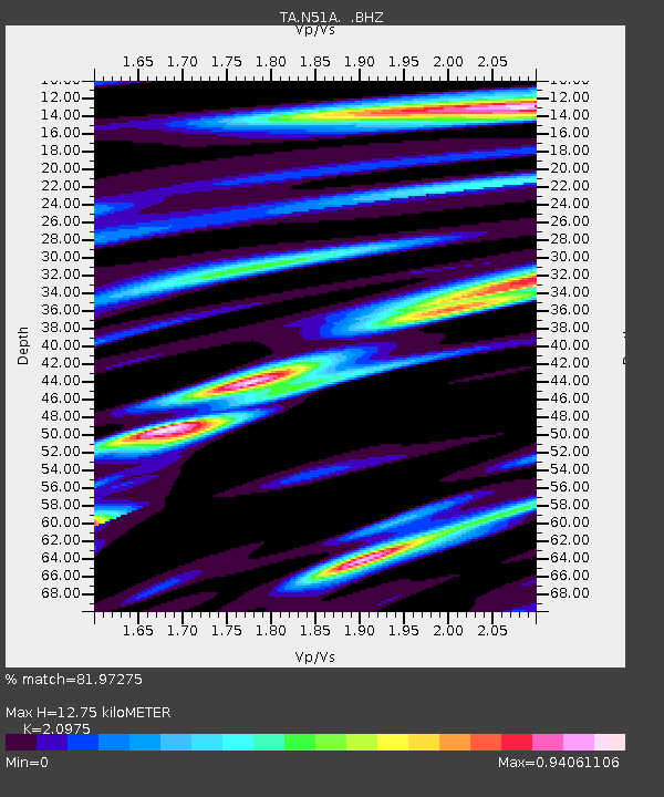
| Estimated Moho Depth: |
12.75 km |
| Estimated Crust Vp/Vs: |
2.10 |
| Assumed Crust Vp: |
6.498 km/s |
| Estimated Crust Vs: |
3.098 km/s |
| Estimated Crust Poisson's Ratio: |
0.35 |
|
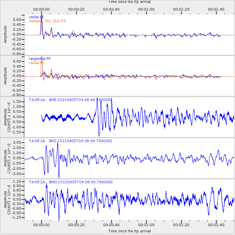
| Radial Match: |
81.97275 % |
| Radial Bump: |
290 |
| Transverse Match: |
61.474804 % |
| Transverse Bump: |
400 |
| SOD ConfigId: |
626651 |
| Insert Time: |
2014-04-18 12:47:56.611 +0000 |
| GWidth: |
2.5 |
| Max Bumps: |
400 |
| Tol: |
0.001 |
|
Signal To Noise
| Channel | StoN | STA | LTA |
| TA:N51A: :BHZ:20130905T04:08:49.749008Z | 8.382189 | 1.4753101E-6 | 1.7600536E-7 |
| TA:N51A: :BHN:20130905T04:08:49.749008Z | 2.8317146 | 5.08599E-7 | 1.7960814E-7 |
| TA:N51A: :BHE:20130905T04:08:49.749008Z | 5.781319 | 9.812478E-7 | 1.6972733E-7 |
| Arrivals |
| Ps | 2.3 SECOND |
| PpPs | 5.7 SECOND |
| PsPs/PpSs | 8.0 SECOND |


