You are here: Home > Network List > TA - USArray Transportable Network (new EarthScope stations) Stations List
> Station O44A Mansfield, IL, USA > Earthquake Result Viewer
O44A Mansfield, IL, USA - Earthquake Result Viewer
| Earthquake location: |
Northern Mid-Atlantic Ridge |
| Earthquake latitude/longitude: |
15.2/-45.2 |
| Earthquake time(UTC): |
2013/09/05 (248) 04:01:36 GMT |
| Earthquake Depth: |
10 km |
| Earthquake Magnitude: |
6.0 MWW, 5.9 MWB, 6.0 MWW, 6.0 MWC |
| Earthquake Catalog/Contributor: |
NEIC PDE/NEIC COMCAT |
|
| Network: |
TA USArray Transportable Network (new EarthScope stations) |
| Station: |
O44A Mansfield, IL, USA |
| Lat/Lon: |
40.15 N/88.47 W |
| Elevation: |
213 m |
|
| Distance: |
45.1 deg |
| Az: |
312.125 deg |
| Baz: |
110.882 deg |
| Ray Param: |
0.071525835 |
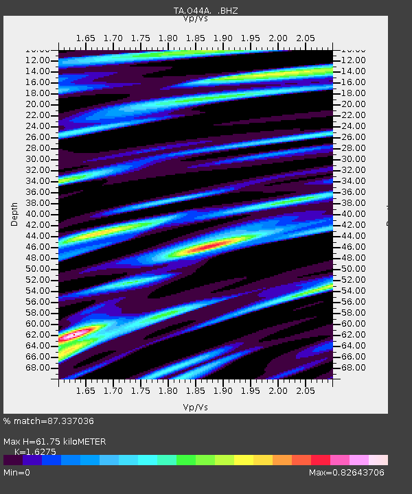
| Estimated Moho Depth: |
61.75 km |
| Estimated Crust Vp/Vs: |
1.63 |
| Assumed Crust Vp: |
6.498 km/s |
| Estimated Crust Vs: |
3.992 km/s |
| Estimated Crust Poisson's Ratio: |
0.20 |
|
| Radial Match: |
87.337036 % |
| Radial Bump: |
400 |
| Transverse Match: |
67.758606 % |
| Transverse Bump: |
400 |
| SOD ConfigId: |
626651 |
| Insert Time: |
2014-04-18 12:48:27.929 +0000 |
| GWidth: |
2.5 |
| Max Bumps: |
400 |
| Tol: |
0.001 |
|
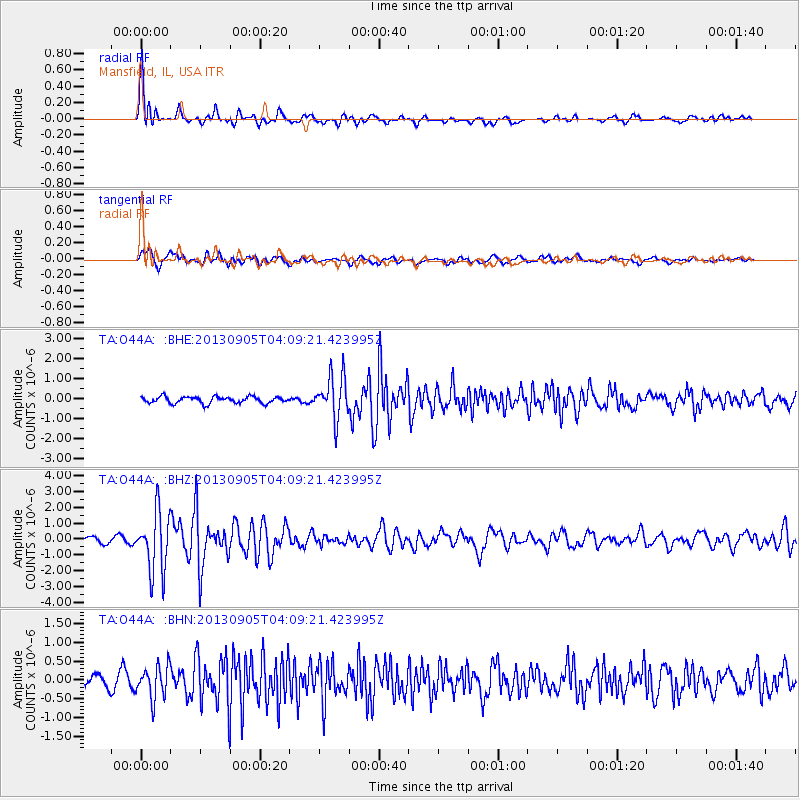
Signal To Noise
| Channel | StoN | STA | LTA |
| TA:O44A: :BHZ:20130905T04:09:21.423995Z | 12.106851 | 1.8748433E-6 | 1.5485806E-7 |
| TA:O44A: :BHN:20130905T04:09:21.423995Z | 2.4454734 | 4.3557912E-7 | 1.781165E-7 |
| TA:O44A: :BHE:20130905T04:09:21.423995Z | 6.534307 | 1.0655084E-6 | 1.6306372E-7 |
| Arrivals |
| Ps | 6.4 SECOND |
| PpPs | 23 SECOND |
| PsPs/PpSs | 30 SECOND |


