You are here: Home > Network List > TA - USArray Transportable Network (new EarthScope stations) Stations List
> Station G59A Clarenceville, QC, USA > Earthquake Result Viewer
G59A Clarenceville, QC, USA - Earthquake Result Viewer
| Earthquake location: |
Greece |
| Earthquake latitude/longitude: |
38.6/23.4 |
| Earthquake time(UTC): |
2014/11/17 (321) 23:05:55 GMT |
| Earthquake Depth: |
8.8 km |
| Earthquake Magnitude: |
5.3 MW, 5.4 mb, 5.0 MS |
| Earthquake Catalog/Contributor: |
ISC/ISC |
|
| Network: |
TA USArray Transportable Network (new EarthScope stations) |
| Station: |
G59A Clarenceville, QC, USA |
| Lat/Lon: |
45.08 N/73.18 W |
| Elevation: |
36 m |
|
| Distance: |
68.0 deg |
| Az: |
310.597 deg |
| Baz: |
57.057 deg |
| Ray Param: |
0.056620214 |
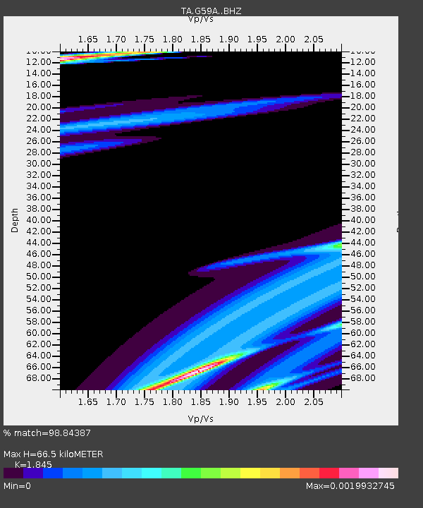
| Estimated Moho Depth: |
66.5 km |
| Estimated Crust Vp/Vs: |
1.85 |
| Assumed Crust Vp: |
6.419 km/s |
| Estimated Crust Vs: |
3.479 km/s |
| Estimated Crust Poisson's Ratio: |
0.29 |
|
| Radial Match: |
98.84387 % |
| Radial Bump: |
93 |
| Transverse Match: |
44.45165 % |
| Transverse Bump: |
317 |
| SOD ConfigId: |
3390531 |
| Insert Time: |
2019-04-15 02:21:22.765 +0000 |
| GWidth: |
2.5 |
| Max Bumps: |
400 |
| Tol: |
0.001 |
|
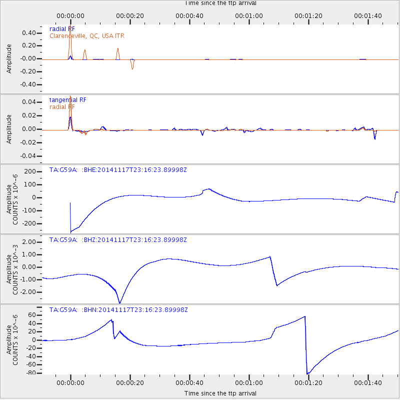
Signal To Noise
| Channel | StoN | STA | LTA |
| TA:G59A: :BHZ:20141117T23:16:23.89998Z | 0.97636294 | 0.002660803 | 0.0027252191 |
| TA:G59A: :BHN:20141117T23:16:23.89998Z | 1.2310847 | 2.3212726E-5 | 1.8855506E-5 |
| TA:G59A: :BHE:20141117T23:16:23.89998Z | 0.7656085 | 7.144945E-5 | 9.3323746E-5 |
| Arrivals |
| Ps | 9.1 SECOND |
| PpPs | 28 SECOND |
| PsPs/PpSs | 37 SECOND |


