You are here: Home > Network List > TA - USArray Transportable Network (new EarthScope stations) Stations List
> Station H17A Grant Village (NPS), Yellowstone Nt. Park, WY, USA > Earthquake Result Viewer
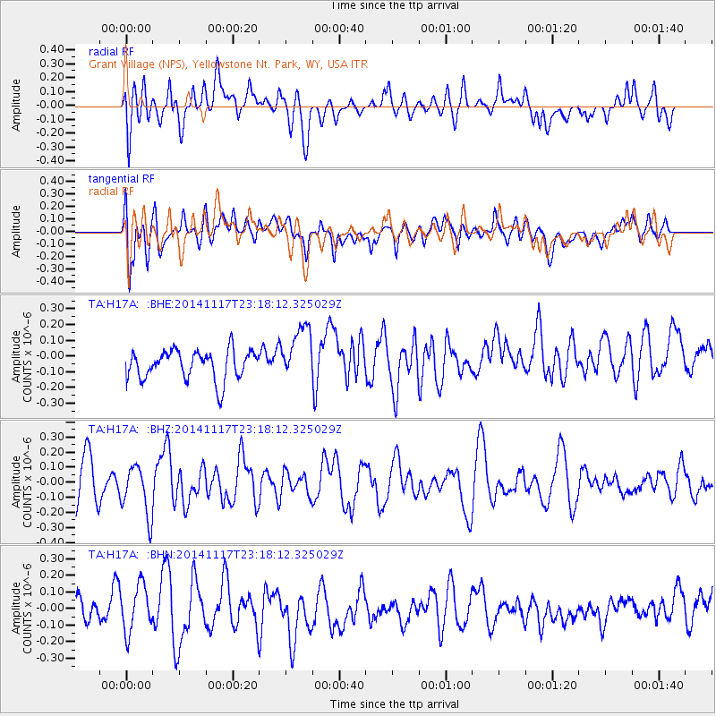
H17A Grant Village (NPS), Yellowstone Nt. Park, WY, USA - Earthquake Result Viewer
*The percent match for this event was below the threshold and hence no stack was calculated.
| Earthquake location: |
Greece |
| Earthquake latitude/longitude: |
38.6/23.4 |
| Earthquake time(UTC): |
2014/11/17 (321) 23:05:55 GMT |
| Earthquake Depth: |
8.8 km |
| Earthquake Magnitude: |
5.3 MW, 5.4 mb, 5.0 MS |
| Earthquake Catalog/Contributor: |
ISC/ISC |
|
| Network: |
TA USArray Transportable Network (new EarthScope stations) |
| Station: |
H17A Grant Village (NPS), Yellowstone Nt. Park, WY, USA |
| Lat/Lon: |
44.40 N/110.58 W |
| Elevation: |
2400 m |
|
| Distance: |
87.5 deg |
| Az: |
328.914 deg |
| Baz: |
34.331 deg |
| Ray Param: |
$rayparam |
*The percent match for this event was below the threshold and hence was not used in the summary stack. |
|
| Radial Match: |
52.900616 % |
| Radial Bump: |
400 |
| Transverse Match: |
65.18957 % |
| Transverse Bump: |
400 |
| SOD ConfigId: |
3390531 |
| Insert Time: |
2019-04-15 02:21:24.749 +0000 |
| GWidth: |
2.5 |
| Max Bumps: |
400 |
| Tol: |
0.001 |
|
Signal To Noise
| Channel | StoN | STA | LTA |
| TA:H17A: :BHZ:20141117T23:18:12.325029Z | 1.3276371 | 1.6955244E-7 | 1.2770992E-7 |
| TA:H17A: :BHN:20141117T23:18:12.325029Z | 1.9374886 | 1.4108093E-7 | 7.281639E-8 |
| TA:H17A: :BHE:20141117T23:18:12.325029Z | 1.9050169 | 1.7752939E-7 | 9.319046E-8 |
| Arrivals |
| Ps | |
| PpPs | |
| PsPs/PpSs | |


