You are here: Home > Network List > TA - USArray Transportable Network (new EarthScope stations) Stations List
> Station O61A Allentown, NJ, USA > Earthquake Result Viewer
O61A Allentown, NJ, USA - Earthquake Result Viewer
| Earthquake location: |
Northern Mid-Atlantic Ridge |
| Earthquake latitude/longitude: |
15.2/-45.2 |
| Earthquake time(UTC): |
2013/09/05 (248) 04:01:36 GMT |
| Earthquake Depth: |
10 km |
| Earthquake Magnitude: |
6.0 MWW, 5.9 MWB, 6.0 MWW, 6.0 MWC |
| Earthquake Catalog/Contributor: |
NEIC PDE/NEIC COMCAT |
|
| Network: |
TA USArray Transportable Network (new EarthScope stations) |
| Station: |
O61A Allentown, NJ, USA |
| Lat/Lon: |
40.09 N/74.55 W |
| Elevation: |
38 m |
|
| Distance: |
35.6 deg |
| Az: |
319.849 deg |
| Baz: |
125.749 deg |
| Ray Param: |
0.07711821 |
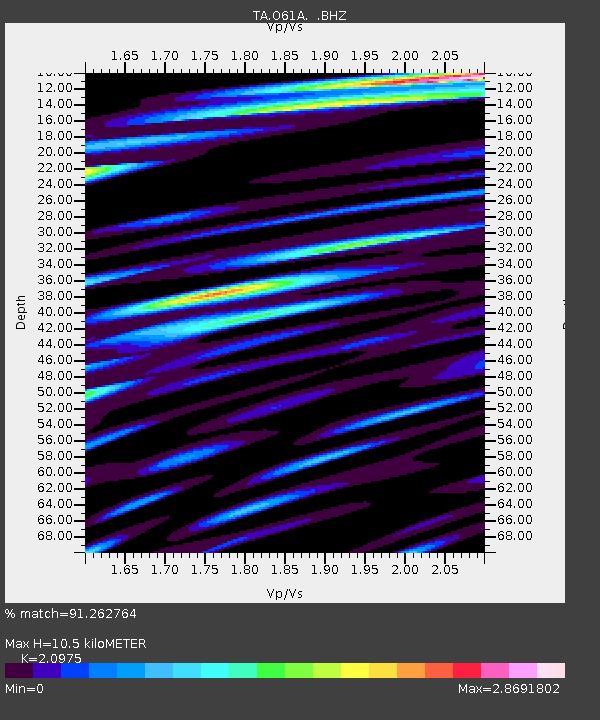
| Estimated Moho Depth: |
10.5 km |
| Estimated Crust Vp/Vs: |
2.10 |
| Assumed Crust Vp: |
6.283 km/s |
| Estimated Crust Vs: |
2.996 km/s |
| Estimated Crust Poisson's Ratio: |
0.35 |
|
| Radial Match: |
91.262764 % |
| Radial Bump: |
366 |
| Transverse Match: |
87.79463 % |
| Transverse Bump: |
400 |
| SOD ConfigId: |
626651 |
| Insert Time: |
2014-04-18 12:49:03.254 +0000 |
| GWidth: |
2.5 |
| Max Bumps: |
400 |
| Tol: |
0.001 |
|

Signal To Noise
| Channel | StoN | STA | LTA |
| TA:O61A: :BHZ:20130905T04:08:03.499008Z | 11.341344 | 1.7854687E-6 | 1.5743008E-7 |
| TA:O61A: :BHN:20130905T04:08:03.499008Z | 5.520224 | 1.4667861E-6 | 2.6571132E-7 |
| TA:O61A: :BHE:20130905T04:08:03.499008Z | 12.197547 | 2.916431E-6 | 2.390998E-7 |
| Arrivals |
| Ps | 1.9 SECOND |
| PpPs | 4.9 SECOND |
| PsPs/PpSs | 6.8 SECOND |


