You are here: Home > Network List > TA - USArray Transportable Network (new EarthScope stations) Stations List
> Station P46A Rosedale, IN, USA > Earthquake Result Viewer
P46A Rosedale, IN, USA - Earthquake Result Viewer
| Earthquake location: |
Northern Mid-Atlantic Ridge |
| Earthquake latitude/longitude: |
15.2/-45.2 |
| Earthquake time(UTC): |
2013/09/05 (248) 04:01:36 GMT |
| Earthquake Depth: |
10 km |
| Earthquake Magnitude: |
6.0 MWW, 5.9 MWB, 6.0 MWW, 6.0 MWC |
| Earthquake Catalog/Contributor: |
NEIC PDE/NEIC COMCAT |
|
| Network: |
TA USArray Transportable Network (new EarthScope stations) |
| Station: |
P46A Rosedale, IN, USA |
| Lat/Lon: |
39.62 N/87.21 W |
| Elevation: |
194 m |
|
| Distance: |
44.0 deg |
| Az: |
311.916 deg |
| Baz: |
111.538 deg |
| Ray Param: |
0.07220863 |
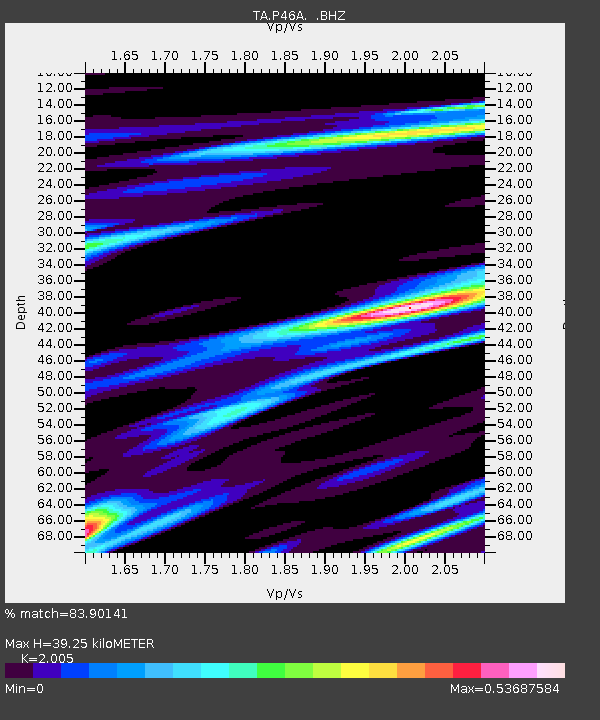
| Estimated Moho Depth: |
39.25 km |
| Estimated Crust Vp/Vs: |
2.01 |
| Assumed Crust Vp: |
6.444 km/s |
| Estimated Crust Vs: |
3.214 km/s |
| Estimated Crust Poisson's Ratio: |
0.33 |
|
| Radial Match: |
83.90141 % |
| Radial Bump: |
318 |
| Transverse Match: |
69.67701 % |
| Transverse Bump: |
400 |
| SOD ConfigId: |
626651 |
| Insert Time: |
2014-04-18 12:49:08.171 +0000 |
| GWidth: |
2.5 |
| Max Bumps: |
400 |
| Tol: |
0.001 |
|
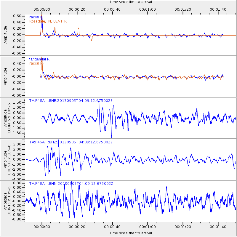
Signal To Noise
| Channel | StoN | STA | LTA |
| TA:P46A: :BHZ:20130905T04:09:12.675002Z | 7.9408045 | 1.6231212E-6 | 2.0440261E-7 |
| TA:P46A: :BHN:20130905T04:09:12.675002Z | 1.4553891 | 3.0475167E-7 | 2.0939531E-7 |
| TA:P46A: :BHE:20130905T04:09:12.675002Z | 3.2753048 | 7.8357016E-7 | 2.392358E-7 |
| Arrivals |
| Ps | 6.5 SECOND |
| PpPs | 17 SECOND |
| PsPs/PpSs | 24 SECOND |


