You are here: Home > Network List > TA - USArray Transportable Network (new EarthScope stations) Stations List
> Station P54A Burton, WV, USA > Earthquake Result Viewer
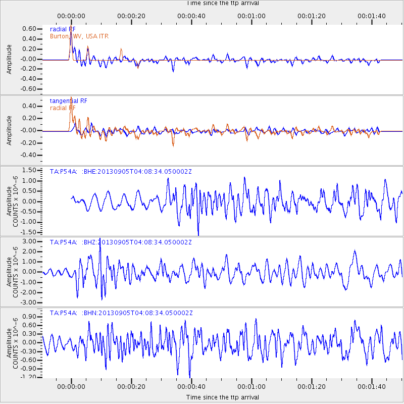
P54A Burton, WV, USA - Earthquake Result Viewer
*The percent match for this event was below the threshold and hence no stack was calculated.
| Earthquake location: |
Northern Mid-Atlantic Ridge |
| Earthquake latitude/longitude: |
15.2/-45.2 |
| Earthquake time(UTC): |
2013/09/05 (248) 04:01:36 GMT |
| Earthquake Depth: |
10 km |
| Earthquake Magnitude: |
6.0 MWW, 5.9 MWB, 6.0 MWW, 6.0 MWC |
| Earthquake Catalog/Contributor: |
NEIC PDE/NEIC COMCAT |
|
| Network: |
TA USArray Transportable Network (new EarthScope stations) |
| Station: |
P54A Burton, WV, USA |
| Lat/Lon: |
39.61 N/80.48 W |
| Elevation: |
473 m |
|
| Distance: |
39.2 deg |
| Az: |
315.198 deg |
| Baz: |
118.269 deg |
| Ray Param: |
$rayparam |
*The percent match for this event was below the threshold and hence was not used in the summary stack. |
|
| Radial Match: |
64.8309 % |
| Radial Bump: |
400 |
| Transverse Match: |
63.889874 % |
| Transverse Bump: |
400 |
| SOD ConfigId: |
626651 |
| Insert Time: |
2014-04-18 12:49:26.571 +0000 |
| GWidth: |
2.5 |
| Max Bumps: |
400 |
| Tol: |
0.001 |
|
Signal To Noise
| Channel | StoN | STA | LTA |
| TA:P54A: :BHZ:20130905T04:08:34.050002Z | 2.9457276 | 9.108739E-7 | 3.0921865E-7 |
| TA:P54A: :BHN:20130905T04:08:34.050002Z | 0.9533711 | 2.256251E-7 | 2.3666031E-7 |
| TA:P54A: :BHE:20130905T04:08:34.050002Z | 1.6491253 | 4.4342363E-7 | 2.6888412E-7 |
| Arrivals |
| Ps | |
| PpPs | |
| PsPs/PpSs | |


