You are here: Home > Network List > TA - USArray Transportable Network (new EarthScope stations) Stations List
> Station Q48A North Vernon, IN, USA > Earthquake Result Viewer
Q48A North Vernon, IN, USA - Earthquake Result Viewer
| Earthquake location: |
Northern Mid-Atlantic Ridge |
| Earthquake latitude/longitude: |
15.2/-45.2 |
| Earthquake time(UTC): |
2013/09/05 (248) 04:01:36 GMT |
| Earthquake Depth: |
10 km |
| Earthquake Magnitude: |
6.0 MWW, 5.9 MWB, 6.0 MWW, 6.0 MWC |
| Earthquake Catalog/Contributor: |
NEIC PDE/NEIC COMCAT |
|
| Network: |
TA USArray Transportable Network (new EarthScope stations) |
| Station: |
Q48A North Vernon, IN, USA |
| Lat/Lon: |
38.93 N/85.73 W |
| Elevation: |
185 m |
|
| Distance: |
42.6 deg |
| Az: |
311.608 deg |
| Baz: |
112.244 deg |
| Ray Param: |
0.073054 |
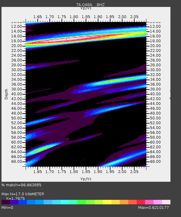
| Estimated Moho Depth: |
17.0 km |
| Estimated Crust Vp/Vs: |
1.77 |
| Assumed Crust Vp: |
6.498 km/s |
| Estimated Crust Vs: |
3.676 km/s |
| Estimated Crust Poisson's Ratio: |
0.26 |
|
| Radial Match: |
86.663895 % |
| Radial Bump: |
349 |
| Transverse Match: |
71.90838 % |
| Transverse Bump: |
400 |
| SOD ConfigId: |
626651 |
| Insert Time: |
2014-04-18 12:49:53.707 +0000 |
| GWidth: |
2.5 |
| Max Bumps: |
400 |
| Tol: |
0.001 |
|
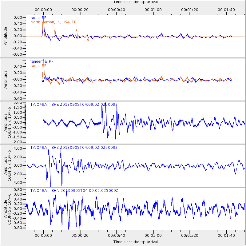
Signal To Noise
| Channel | StoN | STA | LTA |
| TA:Q48A: :BHZ:20130905T04:09:02.025009Z | 6.99939 | 1.9542615E-6 | 2.7920453E-7 |
| TA:Q48A: :BHN:20130905T04:09:02.025009Z | 1.2317616 | 2.779682E-7 | 2.2566722E-7 |
| TA:Q48A: :BHE:20130905T04:09:02.025009Z | 3.7774022 | 7.740349E-7 | 2.0491196E-7 |
| Arrivals |
| Ps | 2.2 SECOND |
| PpPs | 6.8 SECOND |
| PsPs/PpSs | 8.9 SECOND |


