You are here: Home > Network List > TA - USArray Transportable Network (new EarthScope stations) Stations List
> Station Q60A Greensboro, MD, USA > Earthquake Result Viewer
Q60A Greensboro, MD, USA - Earthquake Result Viewer
| Earthquake location: |
Northern Mid-Atlantic Ridge |
| Earthquake latitude/longitude: |
15.2/-45.2 |
| Earthquake time(UTC): |
2013/09/05 (248) 04:01:36 GMT |
| Earthquake Depth: |
10 km |
| Earthquake Magnitude: |
6.0 MWW, 5.9 MWB, 6.0 MWW, 6.0 MWC |
| Earthquake Catalog/Contributor: |
NEIC PDE/NEIC COMCAT |
|
| Network: |
TA USArray Transportable Network (new EarthScope stations) |
| Station: |
Q60A Greensboro, MD, USA |
| Lat/Lon: |
39.00 N/75.84 W |
| Elevation: |
14 m |
|
| Distance: |
35.8 deg |
| Az: |
317.344 deg |
| Baz: |
122.898 deg |
| Ray Param: |
0.07700517 |
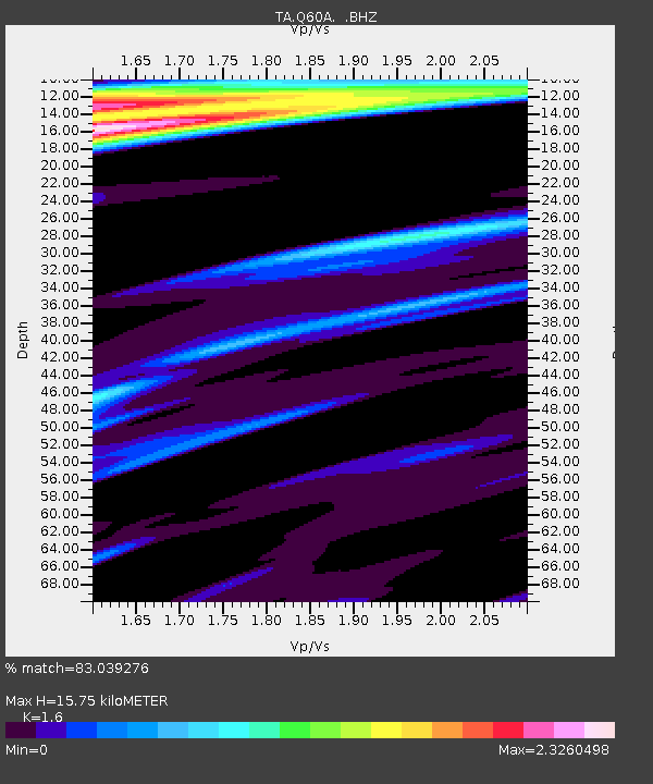
| Estimated Moho Depth: |
15.75 km |
| Estimated Crust Vp/Vs: |
1.60 |
| Assumed Crust Vp: |
6.287 km/s |
| Estimated Crust Vs: |
3.93 km/s |
| Estimated Crust Poisson's Ratio: |
0.18 |
|
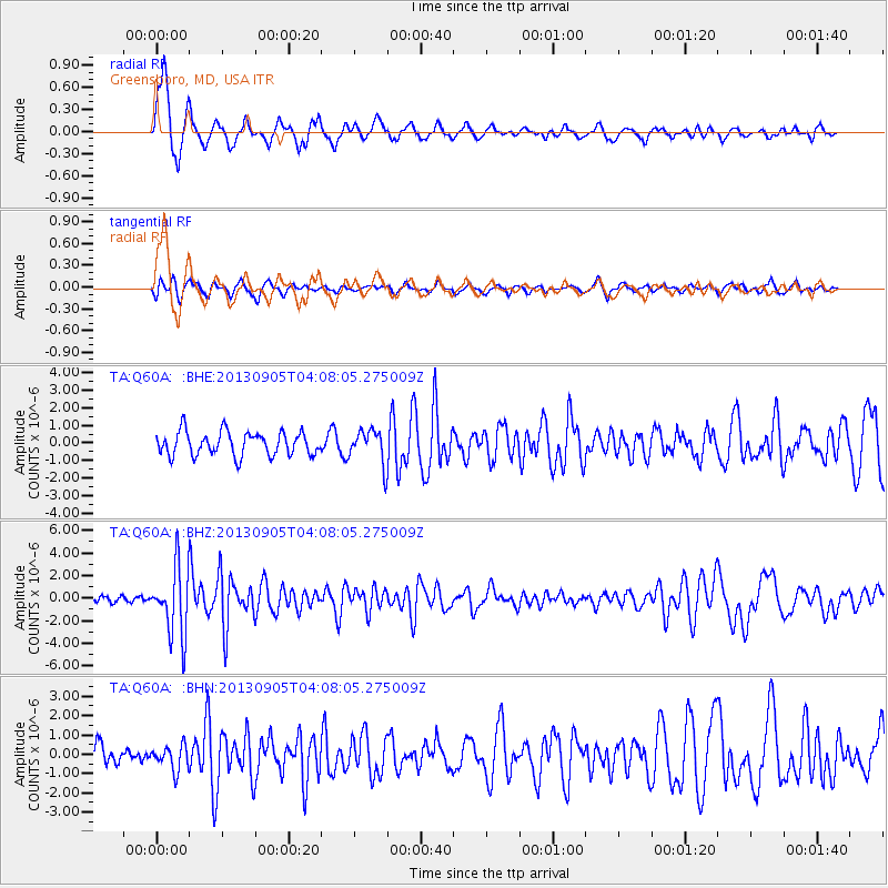
| Radial Match: |
83.039276 % |
| Radial Bump: |
400 |
| Transverse Match: |
58.989742 % |
| Transverse Bump: |
322 |
| SOD ConfigId: |
626651 |
| Insert Time: |
2014-04-18 12:50:23.279 +0000 |
| GWidth: |
2.5 |
| Max Bumps: |
400 |
| Tol: |
0.001 |
|
Signal To Noise
| Channel | StoN | STA | LTA |
| TA:Q60A: :BHZ:20130905T04:08:05.275009Z | 12.131023 | 3.0094945E-6 | 2.480825E-7 |
| TA:Q60A: :BHN:20130905T04:08:05.275009Z | 1.0037569 | 6.3217266E-7 | 6.298066E-7 |
| TA:Q60A: :BHE:20130905T04:08:05.275009Z | 1.4432262 | 9.67283E-7 | 6.7022273E-7 |
| Arrivals |
| Ps | 1.6 SECOND |
| PpPs | 6.0 SECOND |
| PsPs/PpSs | 7.6 SECOND |


