You are here: Home > Network List > TA - USArray Transportable Network (new EarthScope stations) Stations List
> Station S54A Dingess, Beckley, WV, USA > Earthquake Result Viewer
S54A Dingess, Beckley, WV, USA - Earthquake Result Viewer
| Earthquake location: |
Northern Mid-Atlantic Ridge |
| Earthquake latitude/longitude: |
15.2/-45.2 |
| Earthquake time(UTC): |
2013/09/05 (248) 04:01:36 GMT |
| Earthquake Depth: |
10 km |
| Earthquake Magnitude: |
6.0 MWW, 5.9 MWB, 6.0 MWW, 6.0 MWC |
| Earthquake Catalog/Contributor: |
NEIC PDE/NEIC COMCAT |
|
| Network: |
TA USArray Transportable Network (new EarthScope stations) |
| Station: |
S54A Dingess, Beckley, WV, USA |
| Lat/Lon: |
37.80 N/81.31 W |
| Elevation: |
636 m |
|
| Distance: |
39.0 deg |
| Az: |
312.177 deg |
| Baz: |
115.408 deg |
| Ray Param: |
0.075229794 |
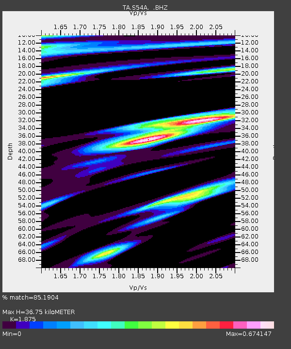
| Estimated Moho Depth: |
36.75 km |
| Estimated Crust Vp/Vs: |
1.88 |
| Assumed Crust Vp: |
6.159 km/s |
| Estimated Crust Vs: |
3.285 km/s |
| Estimated Crust Poisson's Ratio: |
0.30 |
|
| Radial Match: |
85.1904 % |
| Radial Bump: |
355 |
| Transverse Match: |
66.2044 % |
| Transverse Bump: |
400 |
| SOD ConfigId: |
626651 |
| Insert Time: |
2014-04-18 12:51:23.263 +0000 |
| GWidth: |
2.5 |
| Max Bumps: |
400 |
| Tol: |
0.001 |
|

Signal To Noise
| Channel | StoN | STA | LTA |
| TA:S54A: :BHZ:20130905T04:08:32.09999Z | 9.306933 | 1.8173516E-6 | 1.9526857E-7 |
| TA:S54A: :BHN:20130905T04:08:32.09999Z | 2.8556497 | 3.105577E-7 | 1.0875203E-7 |
| TA:S54A: :BHE:20130905T04:08:32.09999Z | 4.400296 | 5.717782E-7 | 1.2994084E-7 |
| Arrivals |
| Ps | 5.6 SECOND |
| PpPs | 16 SECOND |
| PsPs/PpSs | 22 SECOND |


