You are here: Home > Network List > TA - USArray Transportable Network (new EarthScope stations) Stations List
> Station T50A Nancy, KY, USA > Earthquake Result Viewer
T50A Nancy, KY, USA - Earthquake Result Viewer
| Earthquake location: |
Northern Mid-Atlantic Ridge |
| Earthquake latitude/longitude: |
15.2/-45.2 |
| Earthquake time(UTC): |
2013/09/05 (248) 04:01:36 GMT |
| Earthquake Depth: |
10 km |
| Earthquake Magnitude: |
6.0 MWW, 5.9 MWB, 6.0 MWW, 6.0 MWC |
| Earthquake Catalog/Contributor: |
NEIC PDE/NEIC COMCAT |
|
| Network: |
TA USArray Transportable Network (new EarthScope stations) |
| Station: |
T50A Nancy, KY, USA |
| Lat/Lon: |
37.02 N/84.84 W |
| Elevation: |
302 m |
|
| Distance: |
41.3 deg |
| Az: |
309.35 deg |
| Baz: |
111.112 deg |
| Ray Param: |
0.073887356 |
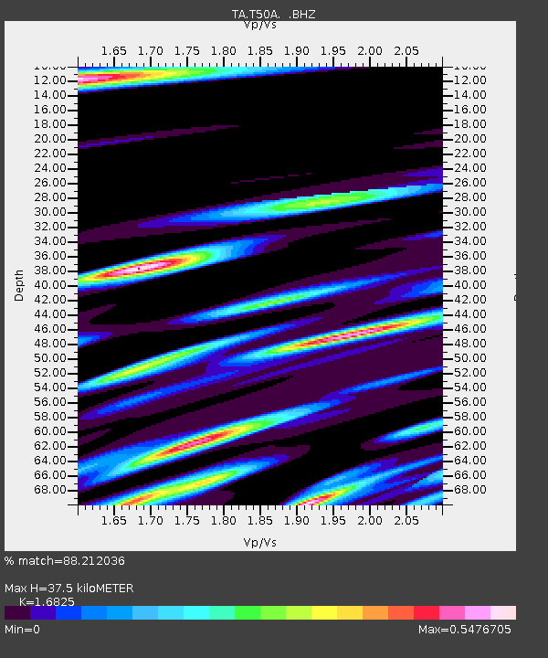
| Estimated Moho Depth: |
37.5 km |
| Estimated Crust Vp/Vs: |
1.68 |
| Assumed Crust Vp: |
6.476 km/s |
| Estimated Crust Vs: |
3.849 km/s |
| Estimated Crust Poisson's Ratio: |
0.23 |
|
| Radial Match: |
88.212036 % |
| Radial Bump: |
286 |
| Transverse Match: |
65.46898 % |
| Transverse Bump: |
400 |
| SOD ConfigId: |
626651 |
| Insert Time: |
2014-04-18 12:51:57.693 +0000 |
| GWidth: |
2.5 |
| Max Bumps: |
400 |
| Tol: |
0.001 |
|
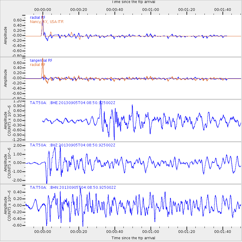
Signal To Noise
| Channel | StoN | STA | LTA |
| TA:T50A: :BHZ:20130905T04:08:50.925002Z | 12.718267 | 9.682336E-7 | 7.612937E-8 |
| TA:T50A: :BHN:20130905T04:08:50.925002Z | 4.783292 | 2.2481028E-7 | 4.6999073E-8 |
| TA:T50A: :BHE:20130905T04:08:50.925002Z | 6.2461996 | 4.7882116E-7 | 7.6658E-8 |
| Arrivals |
| Ps | 4.3 SECOND |
| PpPs | 14 SECOND |
| PsPs/PpSs | 19 SECOND |


