You are here: Home > Network List > TA - USArray Transportable Network (new EarthScope stations) Stations List
> Station T55A Pulaski, VA, USA > Earthquake Result Viewer
T55A Pulaski, VA, USA - Earthquake Result Viewer
| Earthquake location: |
Northern Mid-Atlantic Ridge |
| Earthquake latitude/longitude: |
15.2/-45.2 |
| Earthquake time(UTC): |
2013/09/05 (248) 04:01:36 GMT |
| Earthquake Depth: |
10 km |
| Earthquake Magnitude: |
6.0 MWW, 5.9 MWB, 6.0 MWW, 6.0 MWC |
| Earthquake Catalog/Contributor: |
NEIC PDE/NEIC COMCAT |
|
| Network: |
TA USArray Transportable Network (new EarthScope stations) |
| Station: |
T55A Pulaski, VA, USA |
| Lat/Lon: |
37.12 N/80.78 W |
| Elevation: |
644 m |
|
| Distance: |
38.3 deg |
| Az: |
311.478 deg |
| Baz: |
115.181 deg |
| Ray Param: |
0.075617045 |
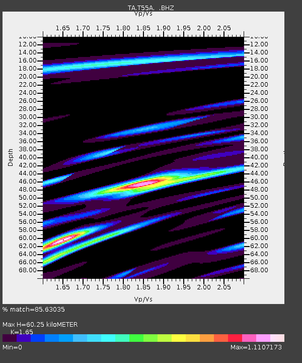
| Estimated Moho Depth: |
60.25 km |
| Estimated Crust Vp/Vs: |
1.65 |
| Assumed Crust Vp: |
6.159 km/s |
| Estimated Crust Vs: |
3.733 km/s |
| Estimated Crust Poisson's Ratio: |
0.21 |
|
| Radial Match: |
85.63035 % |
| Radial Bump: |
285 |
| Transverse Match: |
61.725773 % |
| Transverse Bump: |
400 |
| SOD ConfigId: |
626651 |
| Insert Time: |
2014-04-18 12:52:08.175 +0000 |
| GWidth: |
2.5 |
| Max Bumps: |
400 |
| Tol: |
0.001 |
|

Signal To Noise
| Channel | StoN | STA | LTA |
| TA:T55A: :BHZ:20130905T04:08:26.500015Z | 7.786503 | 1.0862184E-6 | 1.3950016E-7 |
| TA:T55A: :BHN:20130905T04:08:26.500015Z | 1.8044081 | 2.3905233E-7 | 1.3248241E-7 |
| TA:T55A: :BHE:20130905T04:08:26.500015Z | 3.1465569 | 5.266796E-7 | 1.6738285E-7 |
| Arrivals |
| Ps | 6.8 SECOND |
| PpPs | 24 SECOND |
| PsPs/PpSs | 31 SECOND |


