You are here: Home > Network List > TA - USArray Transportable Network (new EarthScope stations) Stations List
> Station U49A Red Boiling Springs, TN, USA > Earthquake Result Viewer
U49A Red Boiling Springs, TN, USA - Earthquake Result Viewer
| Earthquake location: |
Northern Mid-Atlantic Ridge |
| Earthquake latitude/longitude: |
15.2/-45.2 |
| Earthquake time(UTC): |
2013/09/05 (248) 04:01:36 GMT |
| Earthquake Depth: |
10 km |
| Earthquake Magnitude: |
6.0 MWW, 5.9 MWB, 6.0 MWW, 6.0 MWC |
| Earthquake Catalog/Contributor: |
NEIC PDE/NEIC COMCAT |
|
| Network: |
TA USArray Transportable Network (new EarthScope stations) |
| Station: |
U49A Red Boiling Springs, TN, USA |
| Lat/Lon: |
36.51 N/85.78 W |
| Elevation: |
234 m |
|
| Distance: |
41.8 deg |
| Az: |
308.236 deg |
| Baz: |
109.718 deg |
| Ray Param: |
0.073550925 |
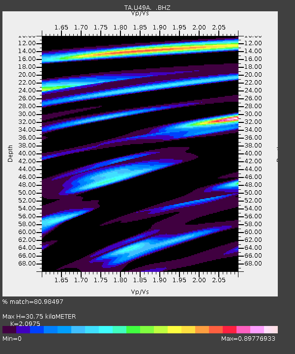
| Estimated Moho Depth: |
30.75 km |
| Estimated Crust Vp/Vs: |
2.10 |
| Assumed Crust Vp: |
6.476 km/s |
| Estimated Crust Vs: |
3.087 km/s |
| Estimated Crust Poisson's Ratio: |
0.35 |
|
| Radial Match: |
80.98497 % |
| Radial Bump: |
355 |
| Transverse Match: |
64.35465 % |
| Transverse Bump: |
400 |
| SOD ConfigId: |
626651 |
| Insert Time: |
2014-04-18 12:52:37.842 +0000 |
| GWidth: |
2.5 |
| Max Bumps: |
400 |
| Tol: |
0.001 |
|

Signal To Noise
| Channel | StoN | STA | LTA |
| TA:U49A: :BHZ:20130905T04:08:55.300002Z | 4.648708 | 9.512912E-7 | 2.0463561E-7 |
| TA:U49A: :BHN:20130905T04:08:55.300002Z | 1.4509903 | 2.0863243E-7 | 1.4378622E-7 |
| TA:U49A: :BHE:20130905T04:08:55.300002Z | 5.1755486 | 5.496686E-7 | 1.06204894E-7 |
| Arrivals |
| Ps | 5.5 SECOND |
| PpPs | 14 SECOND |
| PsPs/PpSs | 19 SECOND |


