You are here: Home > Network List > TA - USArray Transportable Network (new EarthScope stations) Stations List
> Station V48A Smith Brothers Farm, Spring Hill, TN, USA > Earthquake Result Viewer
V48A Smith Brothers Farm, Spring Hill, TN, USA - Earthquake Result Viewer
| Earthquake location: |
Northern Mid-Atlantic Ridge |
| Earthquake latitude/longitude: |
15.2/-45.2 |
| Earthquake time(UTC): |
2013/09/05 (248) 04:01:36 GMT |
| Earthquake Depth: |
10 km |
| Earthquake Magnitude: |
6.0 MWW, 5.9 MWB, 6.0 MWW, 6.0 MWC |
| Earthquake Catalog/Contributor: |
NEIC PDE/NEIC COMCAT |
|
| Network: |
TA USArray Transportable Network (new EarthScope stations) |
| Station: |
V48A Smith Brothers Farm, Spring Hill, TN, USA |
| Lat/Lon: |
35.74 N/86.82 W |
| Elevation: |
278 m |
|
| Distance: |
42.4 deg |
| Az: |
306.741 deg |
| Baz: |
107.996 deg |
| Ray Param: |
0.07321526 |
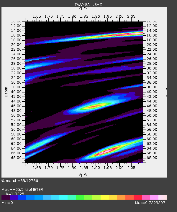
| Estimated Moho Depth: |
65.5 km |
| Estimated Crust Vp/Vs: |
1.93 |
| Assumed Crust Vp: |
6.476 km/s |
| Estimated Crust Vs: |
3.351 km/s |
| Estimated Crust Poisson's Ratio: |
0.32 |
|
| Radial Match: |
85.12786 % |
| Radial Bump: |
320 |
| Transverse Match: |
64.444916 % |
| Transverse Bump: |
400 |
| SOD ConfigId: |
626651 |
| Insert Time: |
2014-04-18 12:53:08.324 +0000 |
| GWidth: |
2.5 |
| Max Bumps: |
400 |
| Tol: |
0.001 |
|
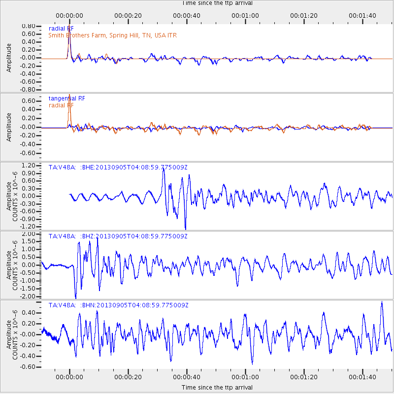
Signal To Noise
| Channel | StoN | STA | LTA |
| TA:V48A: :BHZ:20130905T04:08:59.775009Z | 6.475596 | 9.311172E-7 | 1.4378865E-7 |
| TA:V48A: :BHN:20130905T04:08:59.775009Z | 2.2996154 | 2.0854672E-7 | 9.068766E-8 |
| TA:V48A: :BHE:20130905T04:08:59.775009Z | 4.8096895 | 4.7845805E-7 | 9.947796E-8 |
| Arrivals |
| Ps | 10 SECOND |
| PpPs | 28 SECOND |
| PsPs/PpSs | 38 SECOND |


