You are here: Home > Network List > TA - USArray Transportable Network (new EarthScope stations) Stations List
> Station V60A Jim Taylor Road, Stokes, NC, USA > Earthquake Result Viewer
V60A Jim Taylor Road, Stokes, NC, USA - Earthquake Result Viewer
| Earthquake location: |
Northern Mid-Atlantic Ridge |
| Earthquake latitude/longitude: |
15.2/-45.2 |
| Earthquake time(UTC): |
2013/09/05 (248) 04:01:36 GMT |
| Earthquake Depth: |
10 km |
| Earthquake Magnitude: |
6.0 MWW, 5.9 MWB, 6.0 MWW, 6.0 MWC |
| Earthquake Catalog/Contributor: |
NEIC PDE/NEIC COMCAT |
|
| Network: |
TA USArray Transportable Network (new EarthScope stations) |
| Station: |
V60A Jim Taylor Road, Stokes, NC, USA |
| Lat/Lon: |
35.76 N/77.26 W |
| Elevation: |
8.0 m |
|
| Distance: |
35.2 deg |
| Az: |
311.556 deg |
| Baz: |
117.327 deg |
| Ray Param: |
0.07734807 |
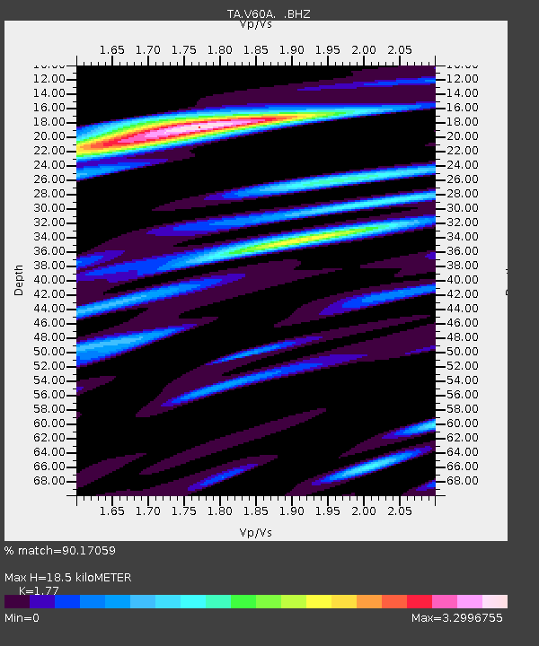
| Estimated Moho Depth: |
18.5 km |
| Estimated Crust Vp/Vs: |
1.77 |
| Assumed Crust Vp: |
6.565 km/s |
| Estimated Crust Vs: |
3.709 km/s |
| Estimated Crust Poisson's Ratio: |
0.27 |
|
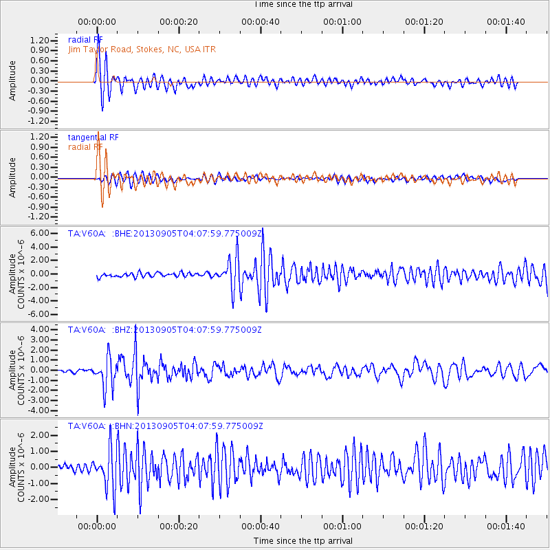
| Radial Match: |
90.17059 % |
| Radial Bump: |
400 |
| Transverse Match: |
69.02691 % |
| Transverse Bump: |
400 |
| SOD ConfigId: |
626651 |
| Insert Time: |
2014-04-18 12:53:37.878 +0000 |
| GWidth: |
2.5 |
| Max Bumps: |
400 |
| Tol: |
0.001 |
|
Signal To Noise
| Channel | StoN | STA | LTA |
| TA:V60A: :BHZ:20130905T04:07:59.775009Z | 14.029644 | 1.4961166E-6 | 1.06639675E-7 |
| TA:V60A: :BHN:20130905T04:07:59.775009Z | 5.016226 | 1.244832E-6 | 2.481611E-7 |
| TA:V60A: :BHE:20130905T04:07:59.775009Z | 7.8064723 | 2.2739464E-6 | 2.9128987E-7 |
| Arrivals |
| Ps | 2.4 SECOND |
| PpPs | 7.2 SECOND |
| PsPs/PpSs | 9.6 SECOND |


